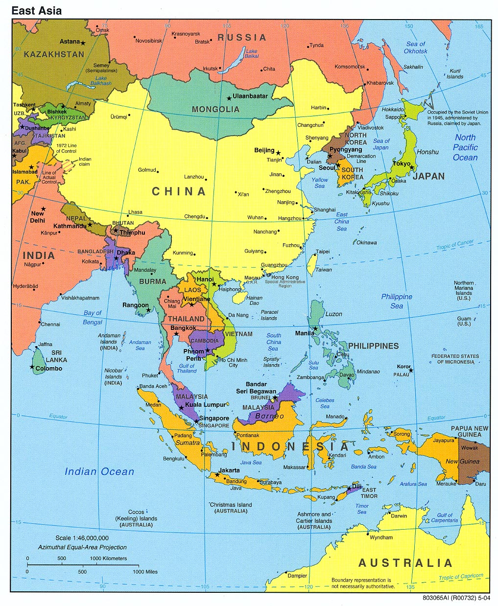
EAST ASIA
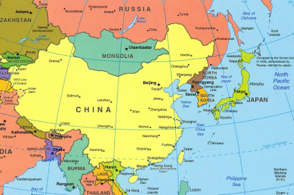
Countries Present in this Region: 6
Mongolia, China, North Korea, South Korea, Taiwan, Japan
Physical Features:
The Plateau of Tibet is a high plateau of southwestern China covering an area of about 965,000 square miles (“Plateau of Tibet,” 2011). This plateau has mountains and uplands that are generally about 13,000-15,000 feet in elevation. The world’s highest peak, Mount Everest, is located within this plateau. It rises 29,035 feet above sea level (“Plateau of Tibet,” 2011). The northern section of the plateau has many salty lakes; the southern section has many headwaters of rivers. Its grasslands are used for pasturage. Barley is grown on the plateau and forests grow on the valleys slopes in the south. The fertile plains of the Brahmaputra River are used for extensive farming. The capital of Tibet, Lhasa, is the “major center of population, economic activity, culture, and air and land transportation” on the plateau (“Plateau of Tibet,” 2011).
The Taklimakan Desert in west-central China forms the greater part of the Tarim Basin to its east. It covers an area of 123,550 square miles and is about 600 miles across (“Takla Makan Desert,” 2011). It is one of the world’s largest sand wastes. On the side of the desert are high mountain ranges such as the Kunlun Moutains; these high mountain ranges have rivers that penetrate the desert nearly 60-120 miles before they dry up in the sands (“Takla Makan Desert,” 2011). The windblown sand cover is almost 1,000 feet thick; it has formed many pyramidal dunes (“Takla Makan Desert,” 2011).
The 3,915 mile long Yangtze River flows northeast and then mainly east across both south-central and east-central China. This river starts in the Tanggula or Dangla Mountains in southwestern China and ends in the East China Sea. It is the world’s third longest river and China and Asia’s longest river (“Yangtze River Facts”). The largest dam, The Three Gorges, is largest in the world and most important and famous section of the river; tourism, flood protection, generation of electricity, and water conservation are among the important aspects (“Yangtze River Facts”). In the minds of Chinese people, this river divides North China and South China (“Yangtze River Facts”) . Along the river’s basin lie many of China’s large cities (Pulsipher & Pulsipher, 2008). In the river valley, many natural resources are present (Pulsipher & Pulsipher, 2008).
The Gobi Desert is located across Central Asia, covering large portions of Mongolia and China. It is one of the great desert and semidesert regions in the world (“Gobi,” 2011). The arc of land it covers is approximately 1,000 miles long and 300-600 miles wide; it covers approximately 500,000 square miles (“Gobi,” 2011). Unlike many other deserts, this desert is not sandy; it is covered with bare rock (“Gobi,” 2011). The Gobi is very dry and cold because it is almost 3,000 feet about sea level. It can be hot and cold in the same day. Temperatures average -40°F for lows and 113°F for highs (White, 2011). This desert has large deposits of gold and copper (White, 2011).
The Hangayn Mountains are located in central Mongolia and extend from the northwest to the southeast for about 500 miles. They then parallel with the Altai Mountains in south Mongolia and rise to 12,812 feet in elevation in the Otgon Tenger Peak (“Hangayn Mountains,” 2011). The steeper southern slope’s rivers end in salt lakes or disappear in the Gobi Desert (“Hangayn Mountains,” 2011). The northern drainage flows into the Selenge River and eventually drains into Siberia’s Lake Baikal. One of the mountains most characteristic features is the gentle slops and crests that are often covered with fine pastures (“Hangayn Mountains,” 2011). The higher central portions, however, are rugged and precipitous (“Hangayn Mountains,” 2011).
Climate:
This region has two totally opposite climate zones; the dry interior west and the wet east. The dry western zone is found in the interior East Asian landmass. Areas in the center of large land masses in the midlatitudes experience very cold winters and intense heat in the summer since land heats up and cools off faster than water (Pulsipher & Pulsipher, 2008). The western part of China, including the Mongolian Plateau and Xinjiang and Quinghai mountains have a midlatitude continental climate that is extreme; temperature differences between day and night can reach 100°F since there is little vegetations and no clouds to keep the sun’s warmth (Pulsipher & Pulsipher, 2008). In this climate zone, several grasslands and different deserts cover much of the land and very few forests grow because of the lack of water. The monsoon or wet climates are found in the east. This huge Eurasian landmass has extremely cold winters and warm summer temperatures because of the nearby seas and oceans; these influence the monsoon climate (Pulsipher & Pulsipher, 2008). The Mongolian Plateau, North China Plain, and far northeast China has very dry, frigid arctic air that blows south and east producing extremely cold winters (Pulsipher & Pulsipher, 2008). In southern China, the monsoon in the winter sometimes causes a freeze. Because central and southern China are protected from the arctic air by mountains and lie close to the South China Sea, they have shorter and less severe winters (Pulsipher & Pulsipher, 2008). As the continent warms up in the summer, the air above it rises and pulls wet tropical air in from the Pacific Ocean and nearby seas. Seasonal rains fall as the warm, wet, ocean air moves above the land. The summer monsoons effect gets weaker as it moves northeasterly; areas in the southeast get dumped with rain and warm weather the majority of the year compared to northern and central China only gets about 5 months of summer monsoon weather (Pulsipher & Pulsipher, 2008). The North China Plain gets about 3 months of monsoon rain, the Inner Mongolia and Northwestern China gets very little rain. China’s Far Northeast, Korea, and Japan have wet climates year long because of their location close to the sea; they also have hot summers and cold winters (Pulsipher & Pulsipher, 2008). Japan and southern Taiwan receive two monsoon rains: once in the summer and once in autumn. North Japan has longer and more severe winters than subtropical Taiwan. The autumn precipitation that falls in Japan usually falls as snow.
Resources:
China has one of the largest and richest mineral stocks of any country. Their most significant minerals include coal, iron, tin, copper, lead, zinc, and mercury. China has one of the world’s largest coal reserves with an estimated 600+ billion tons (“Asia and the Pacific,” 2011). China also has substantial on and off shore petroleum reserves. A number of Western and Japanese companies are assisting China is offshore petroleum prospecting in many locations. These extensive deposits were located in the 1960s (“Asia and the Pacific,” 2011). The North China Plain and Northeast China have the main production centers. China has been ranks as one of the ten world’s largest oil producing countries; they have a capacity to produce more than 1 billion barrels per year (“Asia and the Pacific,” 2011). Small amounts of this output are exported for earning foreign currency. Mining in Mongolia is a relatively new sector for their economy. This country is rich in different natural resources; however, they were under-exploited until the 1970s. The major natural resources of export are copper, gold, molybdenum, and fluorspar (“Asia and the Pacific,” 2011). Mongolia has approximately 100 billion tons of coal reserves; they extract mainly for domestic consumption at about 5.1 million tons per year (“Asia and the Pacific,” 2011). Japan has a lack of adequate minerals and fossil energy. Japan doesn’t have any significant energy reserves besides a small deposit of coal equaling approximately 865 million tons; its major coal deposits were consumed in the 1960s (“Asia and the Pacific,” 2011). North Korea has significant mineral resources; it has the world’s largest magnesite deposits (“Asia and the Pacific,” 2011). Precious and non-ferrous metals are the country’s most important exports. South Korea has no oil or natural gas and very few significant mineral resources. The minerals available include lead, zinc, and copper. Taiwan has small deposits of coal, natural gas, limestone, and marble.
Environmental Issues:
East Asia’s environmental problems either result from their high population density and rapid economic development or from poor resource management and planning. China apparently has some of the planet’s most severe environmental problems (Pulsipher & Pulsipher, 2008). Air pollution is one big issue. China’s industrial output has been growing at about 18% per year which also means that their use of fossil fuel energy is also rising (Pulsipher & Pulsipher, 2008). China uses coal for 65% of their energy needs. Their coal consumption accounts for 40% of the world total; this makes China the world’s largest coal consumer (Pulsipher & Pulsipher, 2008). China’s consumption of coal quadrupled between 1975 and 2005. Because of all this coal burning, it is the cause of the poor air quality in the country; is it also blamed for respiratory problems. Coal combustion releases two pollutants in high levels; sulfur dioxide and suspended particulates (Pulsipher & Pulsipher, 2008). In China’s cities, these emissions can be 10 times the World Health Organization’s guidelines. “The geographic pattern of air pollution in China correlates with patterns of population density, urbanization, and industrialization” (Pulsipher & Pulsipher, 2008). In lightly populated plateau and mountain areas in the north and west, air pollution occurs in the urban areas where there are industries that are concentrated and many homes need to be heated. However, in eastern China, both cities and rural areas have air pollution. Homes and industries are close together and have a high demand on coal for fuel in northeastern China; because of this, the air pollution is the worst here (Pulsipher & Pulsipher, 2008). Sulfur dioxide, formed from the combustion of coal, creates acid rain that is displaced eastwardly. Particulates from coal burning reach as far as the Mediterranean Sea and affects air quality (Pulsipher & Pulsipher, 2008). Eastern China has high levels of vehicle gas emissions and many people are exposed to it. Traditionally, China’s vehicles had high rates of both carbon dioxide and lead emissions; however, the government is increasing their energy policies and going green (Pulsipher & Pulsipher, 2008). It was said that by 2008, all new Chinese cars had to pass lower emission standards than U.S. cars (Pulsipher & Pulsipher, 2008). Water pollution in China is another environmental issue. Health problems costing $4 billion U.S. dollars per year are caused by China’s polluted water and overall scarcity (Pulsipher & Pulsipher, 2008). Only 2/3 of China’s population has access to safe drinking water; 1/3 is left with unsafe drinking water (Pulsipher & Pulsipher, 2008). Lakes, reservoirs, and thousands of miles of China’s waterways have been contaminated by raw sewage and chemicals. Agricultural synthetic nitrogen fertilizers cause much of the pollution. Only 24% of China’s population has access to sanitation (Pulsipher & Pulsipher, 2008). Salt water is coming into aquifers as coastal cities have taken so much water from them in the east. Scientists estimate that about 50% of the groundwater is contaminated that supplies China’s cities (Pulsipher & Pulsipher, 2008). Although these environmental issues are within China, some still do exist in the rest of the region. Japan, North and South Korea, and Taiwan don’t suffer water scarcities as they lie in the northeastern Pacific (Pulsipher & Pulsipher, 2008). All countries of the region have experienced air pollution due to the modern agriculture, industrialization, and urbanized living. The lowest levels of pollution are found in Mongolia and North Korea because of low levels of industrialization (Pulsipher & Pulsipher, 2008). Air pollution is severe enough to cause health problems in the largest cities of Japan, Taiwan, and South Korea (Pulsipher & Pulsipher, 2008).
Population Patterns:
This region is “home to some of the most ancient civilizations on earth” (Pulsipher & Pulsipher, 2008). For over 7,000 years, settled agricultural societies in China have been successful and grown (Pulsipher & Pulsipher, 2008). In eastern China about 2,000 years ago, the basic institutions of government still existing today were established. China was the main source of wealth, technology, and culture for the region until about the 20th century (Pulsipher & Pulsipher, 2008). People have lived in East Asia for hundreds of thousands of years; however, the earliest complex civilizations started in different parts of China about 4,000 years ago (Pulsipher & Pulsipher, 2008). Chinese civilizations evolved from many hearths including the North China Plain. In the north-central China civilization, the majority of the population worked and lived as very poor farmers and laborers. The landowners owed loyalty to the petty kingdoms in China; a single dominant kingdom emerged as a result of a long period of war between the petty kingdoms between 400 and 221 B.C.E (Pulsipher & Pulsipher, 2008).About 2,500 years ago, an idealist named Confucius was interested in reforming governments and eliminating violence from society (Pulsipher & Pulsipher, 2008). This philosophy of Confucian passed through all aspects of Chinese society; it altered the geography of the economic, political, and social aspects, along with influencing gender roles. This philosophy had a lasting effect on the human geography of China as it was used to maintain power and position (Pulsipher & Pulsipher, 2008). The bureaucracy of Confucian let Chinese empires expand, however its sternness led to periods of imperial decline. Nomadic peoples’ invasions from Mongolia and western China helped with the final flow to several successful Chinese empires despite all the defenses (Pulsipher & Pulsipher, 2008). In the 1100’s to the early 1300s, the Chinese were weakened; this means China was conquered and pushed west all the way to Hungary and Poland by the Mongolian military leader and his descendents (Pulsipher & Pulsipher, 2008). China was the world’s most developed region by the tenth century, holding the world’s wealthiest economy, highest living standards, and largest cities. Manchuria invaders from northeastern China overran Beijing and built the Qing Empire; they unified the country and enlarged its borders (Pulsipher & Pulsipher, 2008). Spanish and Portuguese traders found their way to East Asian ports around 1550. In exchange for food crops from the Americas, they wanted silks, spices, and ceramics; this developed an economic expansion spurt and population growth (Pulsipher & Pulsipher, 2008). China’s population was well over 400 million by the 1800’s; many Chinese people were migrating to the empire’s frontiers. European merchants gained access to China’s markets and increased the European influence by the 19th century (Pulsipher & Pulsipher, 2008). Between 1839 and 1895, China lost many wars; the final blow to China’s preeminence was when Japan won the Sino-Japanese war. In the early 20th century, two rival reformist groups rose in China; Japan invaded China is 1937 and killed 10 million Chinese people along with conquering it’s major cities and coastal provinces (Pulsipher & Pulsipher, 2008). The communist revolution changed the picture of living; all areas of economic and social life were reallocated and resulted in better standards of living to the people who needed it. Japan’s active trade with Portugal brought in new ideas and technologies than strengthened the wealthy feudal lords; under a military bureaucracy, Japan was unified starting in 1543 (Pulsipher & Pulsipher, 2008). Japan colonized Korea, Taiwan, and Manchuria and pushed into China and Southeast China further from 1895 to 1945. They wanted to get rid of European imperialism, bigger the resource base and gain labor forces for its mines and factories (Pulsipher & Pulsipher, 2008). Today, East Asia has the highest population of all world regions (Pulsipher & Pulsipher, 2008). People are unevenly distributed throughout the region; for example, China has more than 1/5th of the world’s population but many areas are lightly settled due to the terrain and/or climate.
Role of Gender:
Within China, there is a one-child-per-family policy. This can be devastating to some families if they have a daughter since sons are preferred over daughters in East Asia (Pulsipher & Pulsipher, 2008). In an attempt to reduce the male preference, women are being empowered both socially and economically. However, there are still more men than women. In the region, there are still missing girls despite empowering them socially and economically; there are a few reasons for this. Births may not be reported for girls as they want another chance trying for a boy (Pulsipher & Pulsipher, 2008). Adoptions are higher in girls as compared to boys (Pulsipher & Pulsipher, 2008). They may have been neglected or killed during infancy (Pulsipher & Pulsipher, 2008). Especially in China, a medical test is used to find out the gender of the baby; the fetus may be aborted if it is of female gender (Pulsipher & Pulsipher, 2008). In East Asia, wives in the urban areas perform domestic duties and look after their husbands and children. They also must care for elderly parents or their husband’s parents. Many women cannot take on work outside of the home because East Asian industrial economies are very demanding; workdays are very long and the commutes are long, taking away extra time at home (Pulsipher & Pulsipher, 2008). This is a reason why men fill these duties. Men are expected to be loyal to their work and spend leisure time with business colleagues if they want a promotion. Refusing overtime is considered disloyal; taking time off to be with the family is discouraged also (Pulsipher & Pulsipher, 2008) In general, throughout the region, women who are working make much less than men. If a woman is hired, they are usually a secretary or assistant; they are there to support men and are not full members of corporate teams (Pulsipher & Pulsipher, 2008).
Religions:
The teachings of Confucianism, Taoism, and Buddhism are three of the most important regions within East Asia. Confucianism is “an all-encompassing humanism that neither denies or slights Heaven” (“Religion Facts,” 2011). This religion/philosophy has influenced both the political and spiritual life in China, along with many other East Asian countries. East Asians seldom cease to be Confucians, although they may profess themselves to be Shintoists, Christians, Muslims, Taoists, or Buddhists (Religion Facts,” 2011). Confucius believed that human relationships should involve defined roles and mutual obligations; he thought that if everybody were to follow this set of roles and obligations, a stable and uniform society would form (Pulsipher & Pulsipher, 2008). Values include respect for parents and government officials, courtesy, loyalty, knowledge, and integrity (Pulsipher & Pulsipher, 2008). Taoism is based on Tao Te Ching teachings written in the 6th century in China. Taoism’s emphasis is on spiritual harmony within the individual; this complements Confucianism’s focus on social duty (“Religion Facts,” 2011). Most of the 20 million worldwide followers live in Southeast Asia, China, and Taiwan. Taoism is influential in the West, in fields of alternative medicine and martial arts such as Tai Chi (“Religion Facts,” 2011). Buddhism has developed in a variety of forms from an emphasis on religious rituals of worship of deities to a complete rejection of these and favoring pure meditation. Buddhism has a great respect for Buddha’s teachings of “The Enlightened One” (“Religion Facts,” 2011). This religion’s main locations are found in China, Japan, Korea, and Southeast Asia. According to Buddhism, there is no self or soul as human existence is nothing more than a combination of five impermanent components (Religion Facts,” 2011).
Transportation:
Railways are the most important mode of transportation throughout the region, along with roads and airways. The Qinghai-Tibet Railway opened in 2006 and is the world’s highest railway (Pulsipher & Pulsipher, 2008). Almost 600 miles of the railway are built at above 13,123 feet in elevation (Pulsipher & Pulsipher, 2008). This railway transports both goods and people to and from Tibet, along with adding to Tibet’s main industry of tourism. In China, the most important tool for transportation is railways; more than 50% of China’s traffic is moved by the railway system (“Asia and the Pacific,” 2011). Trunk lines running for north-south and a few east-west lines form a nationwide network. Road conditions in China are poor, but adequate enough to meet the country’s current needs; only 2% of the total freight traffic is by highway networks (“Asia and the Pacific,” 2011). China has 206 airports uses to carry passengers and freight. There are 68,354 miles of navigable waterways in China as well (“Asia and the Pacific,” 2011). Mongolia has a 1,198 mile Trans-Mongolian railway that connects it with Beijing and Moscow (“Asia and the Pacific,” 2011). There are only 30,603 miles of highways and only small chunks are paved in the north (“Asia and the Pacific,” 2011). In the south and southwest, horses and camels are still important modes of transportation. Taiwan has a well planned and efficient transportation network; many of its export businesses rely on both air and sea shipping for the transport of their goods to overseas markets. 90% of Taiwan’s roads are paved (“Asia and the Pacific,” 2011). They have a railways network with 1,542 miles that provides frequent and convenient passenger service between the island’s major cities (“Asia and the Pacific,” 2011). Japan has well-maintained and advanced infrastructure. They have a very extensive and modern road network consisting of 715, 981 miles of highways (“Asia and the Pacific,” 2011). Japan is famous for its high-speed trains; the length of its railways is 14,708 miles (“Asia and the Pacific,” 2011). Japan also has a very extensive and modern sea transportation system since it is surrounded by water and an extensive air transportation system. North Korea has a crumbling infrastructure; it needs expansion and modernization. The limited road system is between 12,400 and 19.344 miles long and isn’t paved (“Asia and the Pacific,” 2011). Its 3,100 mile railway network provides 70% of passenger transport and carries 90% of the yearly freight traffic (“Asia and the Pacific,” 2011). Its ports and airports need modernization. They suffer from an oil and gas shortage. South Korea has had an expansion of land, sea, and air transportation because of the economic growth in the 1990s.
Cuisine:
The East Asian region consists of Chinese, Hong Kong, Japanese, Korean, and Taiwanese cuisines. The cuisine in China is “one of the richest and most diverse culinary heritages in the world” (Wertz, 2011). A typical Chinese culture meal has two general components: a carbohydrate or starch, typically rice, noodles, or steamed buns and dishes of vegetables, fish, or meat (Wertz, 2011). This contrasts Western meals as meat or animal protein is often considered the main dish. Rice is a critical part of the cuisine. Desserts are not often eaten. If there is a dessert served, it is typically fresh fruit such as orange slices or a type of sweet soup made with red beans and sugar; this is served warm (Wertz, 2011). Cold beverages are believed to be harmful in digesting hot foods, so ice cold drinks are usually not served at meal times (Wertz, 2011). It is usually hot tea or hot water as tea is believed to help digest greasy foods. Korean cuisines are served with many side dishes ranging from 2 to 12 (Imatome-Yun, 2011). All dishes are served at the same time, unlike the separate courses in the Western cuisines. Rice is the backbone of the majority of Korean meals (Imatome-Yun, 2011). Rarely, noodles will replace the rice. Each person has their own bowl of soup or stew with meals. The main dish and side dishes, which can be meat, seafood, or tofu, are all served family-style in the middle of the table (Imatome-Yun, 2011). Koreans eat lots of seafood as it is very abundant for them (Imatome-Yun, 2011). They perfect the art of preserving food so the majority of side dishes are pickled, salted, or fermented (Imatome-Yun, 2011).
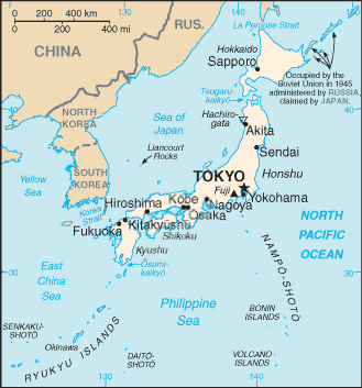
Country of Focus: Japan
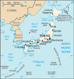
Japan is an island nation located within East Asia; it is an archipelago meaning large group of islands (“Japan,” 2011). It is located east of the Korean peninsula and bordered on the north and east by the Pacific Ocean, the south by the Philippine Sea and East China Sea, and the west by the Sea of Japan and East Sea. Japan’s area is 145,882 square miles with 18,487 miles of coastline (“Japan,” 2011). Japan is prone to earthquakes, tsunamis, and typhoons (Pulsipher & Pulsipher, 2008). Only 18% of its land can be cultivated because of being prone to the severe weather and being so mountainous. Despite all this, Japan houses almost 128 million people (Pulsipher & Pulsipher, 2008).The country’s population is very homogenous, with ethnic Japanese making up 99.4% of the total (“Japan,” 2011). The climate varies between islands. The climate in the north is cool and the climate in the south is tropical. It has the world’s largest ratio of people to farmland; 7,000 plus people rely on each square mile of cultivated land (Pulsipher & Pulsipher, 2008). Japanese agriculture depends on varieties of rice among other crops, as well as irrigation, fertilization, and mechanization. Japan is “one of the world’s largest consumers of foreign agricultural products, especially grains and frozen and processed foods, and it has one of the lowest levels of food self-sufficiency” (Pulsipher & Pulsipher, 2008). This means there is a low percentage of daily food consumed that is supplied by domestic production. Japan has a large and well-developed tourist industry; the mild temperatures, long coast lines, and numerous historical sites make it an attractive destination (“Japan,” 2011). The workforce is Japan is well educated and mostly skilled because of their educational system. Approximately 95% of the workforce worked in urban enterprises (“Japan,” 2011).
References:
Asia and the pacific. (2011). Encyclopedia of the Nations. Retrieved from http://www.nationsencyclopedia.com/economies/Asia-and-the-Pacific/index.html
Gobi. (2011). Encyclopædia Britannica. Retrieved from http://www.britannica.com/EBchecked/topic/236545/Gobi
Hangayn mountains. (2011). Encyclopædia Britannica. Retrieved from http://www.britannica.com/EBchecked/topic/254297/Hangayn-Mountains
Imatome-Yun, N. (2011). Korean food 101. Retrieved from http://koreanfood.about.com/od/koreanfoodbasics/a/Korean101.htm
Japan. (2011). Encyclopedia of the Nations. Retrieved from http://www.nationsencyclopedia.com/economies/Asia-and-the-Pacific/Japan.html
Plateau of tibet. (2011). Encyclopædia Britannica. Retrieved from http://www.britannica.com/EBchecked/topic/594928/Plateau-of-Tibet
Pulsipher, L.M., & Pulsipher, A. (2008). World regional geography: global patterns, local lives (4th ed.).
New York, NY: W.H. Freeman and Company.
Religion facts. (2011). Retrieved from http://www.religionfacts.com/
Takla makan desert. (2011). Encyclopædia Britannica. Retrieved from http://www.britannica.com/EBchecked/topic/581237/Takla-Makan-Desert
The University of Texas at Austin. University of Texas Libraries: Perry-Castaneda Library Map Collection. East asia political map, 2004. Retrieved from http://www.lib.utexas.edu/maps/middle_east_and_asia/asia_east_pol_2004.jpg
The University of Texas at Austin. University of Texas Libraries: Perry-Castaneda Library Map Collection. Japan small map, 2010. Retrieved from http://www.lib.utexas.edu/maps/cia10/japan_sm_2010.gif
Wertz, R. (2011). Food & drink cuisine. Retrieved from http://www.ibiblio.org/chineseculture/contents/food/p-food-c01s01.html
White, D. (2011). The gobi desert; sands and seasons. Retrieved from http://www.socialstudiesforkids.com/articles/geography/gobidesert.htm
Yangtze river facts. (n.d.). Retrieved from http://www.chinahighlights.com/yangtzeriver/yangtze-river-facts.htm
