NORTH AFRICA & SOUTHWEST ASIA
Countries Present in this Region: 20
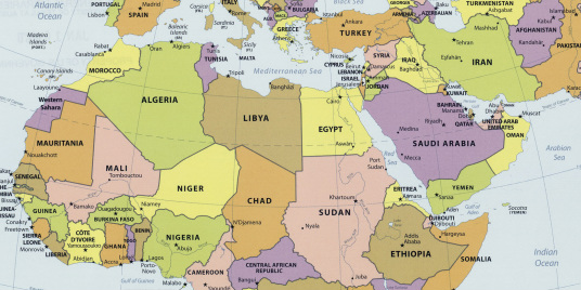
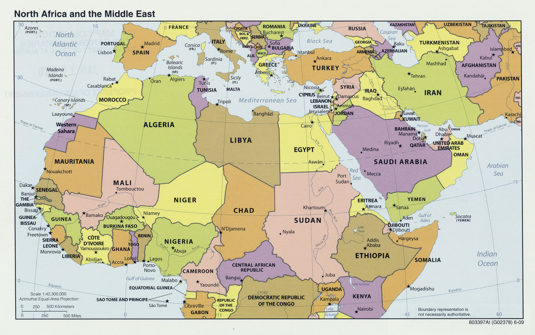
Morocco, Algeria, Tunisia, Libya, Egypt, Sudan, Israel, Lebanon, Syria, Turkey, Iran, Iraq, Jordan, Saudi Arabia, Kuwait, Bahrain, Qatar, United Arab Emirates, Oman, Yemen
Physical Features:
In northwestern Africa lie the Atlas Mountains; these are an extension of the European Alpine System. They extend approximately 1,500 miles from Morocco on the Atlantic coast and Tunisia on the Mediterranean coast (ThinkQuest team, 1998). The highest range of this chain of mountains, called the High or Grand Atlas, is found in southern Morocco. Its highest point, Toubkal, measures 13,665+ feet in elevation (ThinkQuest team, 1998) . These mountains block winds and lift moisture from the Atlantic Ocean; this causes conditions leading to over more than 50 inches of rain annually in some places (Pulsipher & Pulsipher, 2008). In other places, there is enough snowfall to “support a skiing industry” (Pulsipher & Pulsipher, 2008). These mountains provide a route between the northern Atlantic coast and the Sahara Desert. Within these mountain slopes, there is dense cedar, pine, cork, and oak tree-containing forests; fertile valleys and pastures feed the livestock (ThinkQuest team, 1998). There are a variety of mineral deposits that are barely touched; these include lead, zinc, iron, phosphates, gold, and silver.
Starting in Burundi in East Africa, the Nile River flows north 4,132 miles, flowing through both Sudan and Egypt, and emptying into the Mediterranean Sea (ThinkQuest team, 1998). This river is the longest river in the world. In Sudan, the Nile breaks into the Blue Nile that flows east into Ethiopia and the White Nile (Pulsipher & Pulsipher, 2008). This river received its name from the Greek Neilos; it means a valley or river valley. As the river flowed northward, it flooded the Egypt lands and left behind black sediment. As a result of this, the ancient Egyptians called the river black, or Ar/Aur (ThinkQuest team, 1998). All throughout the year, the Nile is a constant source of water enabling farming and irrigation along its banks despite the high temperatures. Not only is it a vital role in agriculture, it is a major source of waterway transportation especially during seasonal flooding when road access isn’t possible (ThinkQuest team, 1998).
The Red Sea is located between Africa and Asia (the Arabian Peninsula); it borders Sudan, Egypt, Saudi Arabia, and Yemen. The Red Sea’s furthest northern point forms the Sinai Peninsula and then continues over 1,000 miles to join the Indian Ocean in the South by the Gulf of Aden (“About the Red Sea,” 2010). It was created over 30 million years ago by the moment of plates in the Earth’s surface. This sea holds numerous living creatures, reefs, and corals. There are over 1000 invertebrate species, over 1000 fish species, and 200 coral types found beneath the crystal blue waters (“About the Red Sea,” 2010). Because of this, the Red Sea attracts divers/snorkelers, photographers, marine scientists, and leisure-seeking tourists. Since the beginning of time, it has been used as a highway between East and West. This waterway is also used for cargo vessels, oil tankers, and fishing boats (“About the Red Sea,” 2010). The Red Sea’s water is a vital asset to surrounding cities as they are dependent upon it for household and industrial supplies; there are numerous desalination plants in operation to supply high standard, purified drinking water (“About the Red Sea,” 2010).
The Libyan Desert is located in the northeastern part of the Sahara Desert in Africa. This desert is located within southwestern Egypt, eastern Libya, and northwestern Sudan. In Egypt, this desert is known as the Western Desert (“Libyan Desert,” 2008). Its area is filled with sand dunes, stony plains, and rocky plateaus; few inhabitants are found here, and there is little traffic coming through it (“Libyan Desert,” 2008). This area is harsh, arid, and inhospitable. Its highest point is at 6,345 feet where the three countries meet; the lowest point, Qattara Depression of Egypt, goes 436 feet below sea level (“Libyan Desert,” 2008).
In northeastern Sudan lies the Nubian Desert. The Nile River valley separates this desert from the Libyan Desert in the west and the Red Sea in the east; it is separated in the north by Egypt and in the south by the Nile River (“Nubian Desert,” 2011).This desert’s terrain is rocky and rugged, containing some dunes. Toward the Red Sea in the east, gentle slopes rise into the Red Sea Hills which are steep uplands. Jabal Erba, part of the Red Sea Hills, rise to 7,273 feet in elevation (“Nubian Desert,” 2011). This is a sandstone plateau with seasonal rivers that don’t reach the Nile River as they die out (“Nubian Desert,” 2011). This area is somewhat arid; less than 5 inches of rainfall is recorded each year.
Climate:
This region’s climate is the most extensive and widespread dry climate in the world. A “global belt of dry air” creates desert climates in the northern portion of North Africa (the Sahara), the Arabian Peninsula, Iran, and Iraq (Pulsipher & Pulsipher, 2008). Because of the Sahara’s size and southern location, it is a very hot desert region; temperatures in the shade can reach up to 130°F (Pulsipher & Pulsipher, 2008). Temperatures at night drop fast as there isn’t any water or vegetation that keeps in the heat. The rainfall on the “uplands and margins of the deserts on both the African and Euransian continents” provides nurturing to grass and limited trees and agriculture (Pulsipher & Pulsipher, 2008). Areas in the west side of Morocco, northern Algeria, Tunisia, Iraq, Turkey, and Iran get this rainfall (Pulsipher & Pulsipher, 2008). The rest of the areas in this region are too arid for cultivation so they are used for nomad herding lands. Because the Atlas Mountains “block and life moisture-laden winds from the Atlantic,” rainfall can reach up to 50 inches per year in some areas (Pulsipher & Pulsipher, 2008). To the south and east of the Atlas Mountains, rainfall is scarce and unpredictable.
Resources:
This region is known for some of the world’s largest oil and natural gas reserves; they are located around the Persian Gulf (Pulsipher & Pulsipher, 2008). The oil wealth lies within bordering countries of the Gulf including the United Arab Emirates, Qatar, Oman, Iraq, Iran, Kuwait, and Saudi Arabia, along with Algeria, Tunisia, Libya, and Sudan in North Africa (Pulsipher & Pulsipher, 2008). European and North American companies exploited these oil reserves; the oil was drilled and processed at foreign owned on-site companies; it was sold to Europe, the US, and Japan at a very low cost in the early 20th century. These countries producing oil have what is known as a cartel called OPEC, the Organization of Petroleum Exporting Countries (Pulsipher & Pulsipher, 2008). This cartel restricts oil production and raises the oil prices; consumers can also affect the prices. Within the region, it has brought wealth in to both the oil-producing and non oil-producing countries. This wealth benefited the roads, airports, irrigation of agriculture, among other things. However, much less money is invested in education, social services, and health care (Pulsipher & Pulsipher, 2008). Pipelines carry crude oil to refineries to convert it into useful products and also transport it to ports on the Persian Gulf, Red Sea, and Mediterranean Sea; tankers then carry it to the world markets (“Southwest Asia,” n.d.).North Africa is one of the wealthiest mineral places in the continent. Mineral resources include coal, petroleum, iron ore, copper, lead, zinc, phosphates, and diamonds, among many other minerals (“Africa Resources,” 2011). North Africa has major coal deposits (“Africa Resources,” 2011). In Southwest Asia, major coal deposits are found in Iran and Turkey. In many parts of the region, water is a valuable resource; areas with plentiful water include Turkey, Iran, and Lebanon (“Southwest Asia,” n.d.). This water is used for hydroelectric power.
Environmental Issues:
The availability of water in this region is very limited because of its arid climate. People in this region have established coping mechanisms and use little water to conserve what they have. These mechanisms include: establishing buildings to increase shaded areas, taking the melted snow and moving it to dry fields, and cleansing themselves in public baths (Pulsipher & Pulsipher, 2008). Many people practice many water recycling techniques as water is important to many people, especially to the religious practice of the Muslims. Some contributing factors to the water shortage include: plumbing, sewage treatments, and agricultural irrigation (Pulsipher & Pulsipher, 2008). It is estimated that by 2025, this region will not have the amount f water that the United Nations establishes necessary (Pulsipher & Pulsipher, 2008). The biggest use of the region’s water is for irrigating agriculture; the chemicals used for agriculture are contaminating the water in the rivers and streams. This region is trying to increase its water supply by building dams and reservoirs on the major river systems, but it also has its problems. Damming these major river systems will stop the fertile soil deposits occurring from flooding; it could also flood upstream villages for fields (Pulsipher & Pulsipher, 2008). It seems as every effort to try and increase the region’s water supply comes with problems. Another issue is desertification; this happens when non-desert land is changed to deserts. This process involves losing the moisture in the soil or even soil erosion, loss of vegetation, and replacement of certain plant species with desert-like species (Pulsipher & Pulsipher, 2008). This could be caused by human activity, climate change, forest and grassland modification, or even overusing what water resources the region has (Pulsipher & Pulsipher, 2008). In this specific region, nomadic herders are causing the increasing desertification; their animals overgraze the land which leaves little grass and little moisture in the soil. Nowadays, however, studies are showing that the herders are careful in letting the grass re-grow; they are more likely to decrease their herds instead of increasing them (Pulsipher & Pulsipher, 2008). Economic changes contribute to the Sahara’s bordering grasslands. Because groundwater levels are decreasing due to irrigation and other things, plant roots cannot reach areas of moisture anymore (Pulsipher & Pulsipher, 2008).
Population Patterns:
The many nomadic people of this region built agricultural communities between 10,000 and 8,000 years ago (Pulsipher & Pulsipher, 2008). These communities were the only ones in the world at the time and were located along the fertile land areas of the Tigris and Euphrates Rivers. They soon gained many skills for domesticating plants and animals as they became for familiarized with the fresh water supply and open grasslands. With these new skills, they were able to establish more establishments; these, in time, turned into societies (Pulsipher & Pulsipher, 2008). The Ottoman Empire, the world’s greatest Islamic empire, began in the 1200’s. Soon, the eastern Mediterranean and Egypt was controlled by the Ottomans; the majority of southeastern/central Europe was Ottoman controlled by the late 1400s (Pulsipher & Pulsipher, 2008). After World War I, the Ottoman Empire fell. After World War II, the Jews who survived the Nazi death camps had nowhere to go as no country offered them a place to go. Land was created for them in Palestine, and in 1949 a Jewish state was created for the Jews (Pulsipher & Pulsipher, 2008).
This whole region is almost twice the size of the United States, but the areas that support agriculture and population settlements are much smaller (Pulsipher & Pulsipher, 2008). In areas that are considered livable, such as in Egypt’s urban neighborhoods, population densities are very high; they can reach up to 260,000 people per square mile (Pulsipher & Pulsipher, 2008). Much of the desert land is not inhabited as most people live along the coastal zones, river valleys, and areas of upland that receive rainfall. This region has the second highest fertility rates even after declining from 9 children per women in the 1960’s to around 3.5 in 2005 (Pulsipher & Pulsipher, 2008). The region’s population is estimated at approximately 450 million people and is expected to increase 90 million people by 2025 for a total of 540 million people (Pulsipher & Pulsipher, 2008). With this many people, the region is going to have a major problem since much of its food is imported, the freshwater availability is already scarce, and the demand for jobs will increase. The scarcity and hardships of finding a job in the region leads to people emigrating to other areas of the world in search for a job; much emigration consists of young males (Pulsipher & Pulsipher, 2008). Areas of the Arabian Peninsula have guest workers to modernize work environments. In other areas of the region, immigration is popular. Migration to urban areas from rural villages is becoming the trend; 58% of the population was living in urban areas in 2005. There are a total of 35 cities in this region with a million or more people and 120 cities with a 100,000 or more. Millions of refugees reside in this region looking to escape from human conflict (Pulsipher & Pulsipher, 2008).The world’s largest refugee population consists of Palestinians; they make up at least 5 million people (Pulsipher & Pulsipher, 2008).
Role of Gender:
In this region at one time, courtyards were used as private places for the females. Because the females were only to be in private places, the males went out to public places such as markets, town squares, and shops to make money and alliances to support and advance family interests (Pulsipher & Pulsipher, 2008). If men are able to accomplish arrangements such as finding the best prices for appliances or cars, finding mates for their children, or finding a job, they gain a lot of family respect.Today, both men and women go into public places; women just have a harder time entering. In Saudi Arabia, there is strict exclusion; women should only be in public places for important business and they should be with a male relative if they are out in public (Pulsipher & Pulsipher, 2008). Rural women in Egypt perform duties outside of the home such as agriculture, water carrying, and gathering firewood. Islamic societies of Iraq, Lebanon, Egypt, Turkey, Libya, Tunisia, and Morocco have females perform activities requiring them to be in public places (Pulsipher & Pulsipher, 2008). In the most conservative areas, the rates of “female doctors, lawyers, teachers, and business people” are rising (Pulsipher & Pulsipher, 2008). The reason behind why women are hid while entering public places in the idea that her honor needs to be maintained. They must wear modest street clothing and usually travel in groups in public. In order to maintain their honor again, single women may take a younger male sibling along (Pulsipher & Pulsipher, 2008). High fertility rates are found in rural areas as families rely on their children for labor supplies. Fewer children are found in urban areas when women work/study outside of the home. Children are important for both family involvement and women’s power when the men have higher education levels and better access to employment (Pulsipher & Pulsipher, 2008). Women who are confined to their home are undereducated and have a difficult time gaining wealth, prospects, and reputation for their family (Pulsipher & Pulsipher, 2008). Instead, they contribute their work and goodwill to the “reproduction, health, and well-being” of their families (Pulsipher & Pulsipher, 2008).
Religions:
This region’s religions believed in many gods many, many years ago. Monotheistic belief systems, or beliefs in only one god, emerged a few thousand years ago (Pulsipher & Pulsipher, 2008). Followers of Islam contribute to 93% or more of the population in this region today. The two primary groups of Islam are the Shiites and Sunni. Islamic central teachings are demonstrated by the 5 Pillars of Islamic Practice (Pulsipher & Pulsipher, 2008). There is only one pillar about articles of faith; the other four are things to do in one’s daily life. With this said, Islamic practice is a huge part of their daily life (Pulsipher & Pulsipher, 2008). Shari’a, the religious law of Islam, uses the principles of Qur’an (Islamic holy book) to guide daily life. There is a large debate on the religion’s role in society in Muslim communities; generally, Islam’s haven’t seen religion separate from state in the West. Christianity is based on Jesus of Nazareth teachings; Jesus of Nazareth was a Jew who, 2,000 years ago, gathered followers in the Palestine area (Pulsipher & Pulsipher, 2008). Jesus, also known as Christ, teaches its followers that there is only one god; God’s relationship to humans is through love and support and will judge people who are or do evil. He was executed from Jerusalem in 32 C.E.; his teachings were written down by his followers and because of this, the ideas and teachings spread (Pulsipher & Pulsipher, 2008). These ideas and teachings were named Christianity. Christianity was the official Roman Empire Religion by 400. The spread of Islam after 622 C.E. resulted in only a few Christianity remnants remaining “in the eastern Mediterranean, North Africa, and Central and South Asia” (Pulsipher & Pulsipher, 2008). Christians launched crusades to take the eastern Mediterranean from the Islamic; later on, Christianity spread throughout the European colonization as missionary activities were spread to the Americas, Africa, and Asia (Pulsipher & Pulsipher, 2008).
Transportation:
Modes of transportation in this region include roadways, railways, airways, and waterways. Egypt has a well-developed transportation system; they have 39,770 miles of paved roadways as of 2002 and 92 airports (“Africa,” 2011). In Sudan, there are 3,297 miles of waterways; river transport services link many of the communities (“Africa,” 2011). The White Nile waterway is very important along with the Red Sea’s Port Sudan as it is used for Sudan’s cotton exports and the majority of its food imports. Railroad tracks in Sudan link the majority of its towns. In Libya, transportation ways vary from dirt tracks for camels to a coastal highway extending 1,132 miles (“Africa,” 2011). Libya’s railways were closed down in the 1960’s and there has been little progress on the plans to reconstruct them. Iran had a total of 322 airports in 2001; their state-owned air system provides frequent services to 15 in-country cities and is also an international carrier (“Asia & Oceania,” 2011). In Saudi Arabia, until recent decades, camel was the main mode of transportation. Now, highways, railroads, and airways are used; the majority of freight staying within the country is hauled by truck (“Asia & Oceania,” 2011).
Agriculture:
This region was home to “some of the very earliest agricultural societies” in earlier times (Pulsipher & Pulsipher, 2008). However, changes in climate, and the overuse of soils and irrigation have limited the possible agriculture areas within the region. The Mediterranean coastal areas grow many vegetables, citrus fruits, grapes, and olives because they receive rainfall in the winter and use supplemental irrigation. Major river valleys grow cotton, wheat, barley, and many vegetables because of the seasonal flooding they receive. The Nile Valley, located in Sudan and Egypt, support the growth of cotton, rice, grains, sugarcane, peanuts, corn, and fruit (Pulsipher & Pulsipher, 2008). The Tigris and Euphrates river valleys produce tobacco, livestock, cotton, and sugar beets. The Arabian Peninsula produces coffee. Once again, because of the dry climate, agriculture is scare and needs irrigation (Pulsipher & Pulsipher, 2008).
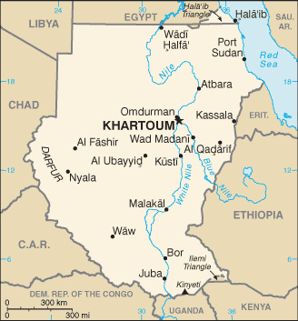
Country of Focus: Sudan

Sudan is the largest country in both this region and all of Africa; it is about ¼ the size of the US (Pulsipher & Pulsipher, 2008). The total population is approximately 42 million people which is half the amount of Egypt’s population. The majority of Sudan’s area is desert and dry, vast grassland plains. The Nile River system, with its two chief tributaries of the White Nile and Blue Nile run through this country; this system is the country’s major source of water (Pulsipher & Pulsipher, 2008). Most of Sudan’s population lives in narrow strips of rural villages along the river system. The only cities lie where the White and Blue Niles join together, known as the capital of Khartoum (Pulsipher & Pulsipher, 2008). Religions vary within the region; Islam is found in northern Sudan whereas Christian or indigenous beliefs are found in southern Sudan. In the south, black Africans from Dinka or Nuer ethnicity reside. Water shortages inhibit agriculture, animal breeding, and human settlement in a large part of Sudan. Sudan’s scarce renewable water resources are mainly used for farming; only 1% is used for domestic purposes (“Sudan,” 2011). The country’s coastal waters are polluted by industrial by-products, sewage, and oil. In 2000, only 75% of the population had access to safe drinking water. The average life expectancy was 56 years and the infant mortality rate was 81 per 1,000 live births in 2000 (“Sudan,” 2011). As of 1999, the prevalence of HIV was 1:100 adults.
References:
About the red sea. (2010). Tour Egypt. Retrieved from http://www.touregypt.net/vdc/abtrdsea.htm
Africa. (2011). Encyclopedia of the Nations. Retrieved from http://www.nationsencyclopedia.com/Africa/index.html
Africa resources. (2011). Encylopaedia Britannica. Retrieved from http://www.britannica.com/EBchecked/topic/7924/Africa/37210/Resources
Asia & oceania. (2011). Encyclopedia of the Nations. Retrieved from http://www.nationsencyclopedia.com/Asia-and-Oceania/index.html
Libyan desert. (2008). The Columbia Encyclopedia, Sixth Edition. Retrieved from http://www.encyclopedia.com/doc/1E1-LibyanDe.html
Nubian desert. (2011). Encyclopaedia Britannica. Retrieved from http://www.britannica.com/EBchecked/topic/421505/Nubian-Desert
Pulsipher, L.M., & Pulsipher, A. (2008). World regional geography: global patterns, local lives (4th ed.).
New York, NY: W.H. Freeman and Company.
Southwest asia [PowerPoint slides]. (n.d.) Retrieved from http:// www.forsyth.k12.ga.us/
Sudan. (2011). Encyclopedia of the Nations. Retrieved from http://www.nationsencyclopedia.com/Africa/Sudan.html
The University of Texas at Austin. University of Texas Libraries: Perry-Castaneda Library Map Collection. North Africa and the middle east political map, 2009. Retrieved from http://www.lib.utexas.edu/maps/africa/n_africa_mid_east_pol_2009.jpg
The University of Texas at Austin. University of Texas Libraries: Perry-Castaneda Library Map Collection. Sudan small map, 2010. Retrieved from http://www.lib.utexas.edu/maps/cia10/sudan_sm_2010.gif
ThinkQuest team. (1998). The land. The Living Africa. Retrieved from http://library.thinkquest.org/16645/the_land/the_land.shtml
