SUB-SAHARAN AFRICA
Countries Present in this Region: 47
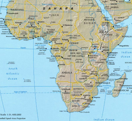
Mauritania, Senegal, The Gambia, Guinea-Bissau, Guinea, Sierra Leone, Liberia, Cote D’Ivoire, Burkina Faso, Mali, Niger, Ghana, Togo, Benin, Nigeria, Cameroon, Equatorial Guinea, Gabon, Republic of Congo, Central African Republic, Chad, Democratic Republic of the Congo, Uganda, Rwanda, Burundi, Tanzania, Kenya, Ethiopia, Somalia, Djibouti, Eritrea, Angola, Namibia, South Africa, Lesotho, Swaziland, Botswana, Zimbabwe, Zambia, Mozambique, Malawi, Madagascar, Cape Verde, Sao Tome & Principe, Comoros, Seychelles, Mauritius
Physical Features:
The Congo River is the second longest river in Africa and the fifth longest in the world. It flows through the Democratic Republic of the Congo, the Republic of Congo, the Central African Republic, and partially through Zambia, Angola, Cameroon, and Tanzania (ThinkQuest, 1998). It forms in the most southern part of the Democratic Republic of the Congo; it first loops northeast, westward, and then southward reaching the Atlantic Ocean. It is 2,720 miles long and the width ranged from a half mile to 10 miles depending on the time of year and location (ThinkQuest, 1998). The rivers outlet can pour out up to 1.2 million cubic feet of water per second (ThinkQuest, 1998). This river has many tributaries and account for over 9,000 miles of navigable water transportation routes across Central Africa; it is the biggest transportation source in Central Africa (ThinkQuest, 1998).
Located in the Sahel zone of west-central Africa, Lake Chad is the fourth largest African lake (ThinkQuest, 1998). It lies between Chad, Cameroon, Nigeria, and Niger. Depending on the water level, the surface area varies. If the water rises about 930 feet above sea level, the area is approximately 6,875 square miles (ThinkQuest, 1998). Lake Chad is very important to Africa as it contributes to the region’s hydrology; it also has a diversity of flora that attracts different animal life (ThinkQuest, 1998). The Lake Chad region has an important role in trans-Saharan trade; this is what it is known for. Various archaeological discoveries have been made here also.
The largest lake in Africa is known as Lake Victoria; it is the second-largest freshwater lake in the world, right behind Lake Superior in the United States (ThinkQuest, 1998). It is the Nile River’s main reservoir. It is located primarily in Tanzania and Uganda, and partially extends into Kenya. It occupies about 26,800 square miles (ThinkQuest, 1998). It is 210 miles long from north to south and 150 miles wide from east to west; it has 2,000+ miles of coastline (ThinkQuest, 1998). The lake reaches a depth of 270 feet. There are many reefs just below the surface and over 200 species of abundant fish. These fish make a major contribution to the economy as local fishermen export them (ThinkQuest, 1998).
The Ituri Forest is located in the northern part of the Congo River Basin in the Democratic Republic of Congo. This dense tropical rain forest covers over 24,300 square miles of land (ThinkQuest, 1998). The altitude ranges from 2,300 feet in the south to 3,300 feet in the north. The forest’s boundaries are difficult to define as it blends with other swamp regions and forests. It borders savanna in the north, the Western Rift Valley in the east, and lowland rainforest to both the south and west (ThinkQuest, 1998). This forests name is derived from the Ituri River which flows from east to west across the forest (ThinkQuest, 1998). The landscape of this forest contains rich groups of birds and mammals; there is a major population of the local okapi (“Ituri Forest”. The forest is also a globally important reservoir of diverse flora. Within the landscape, approximately 30,000 nomadic hunter-gatherers live throughout (“Ituri Forest”).
The Kalahari Desert spans Botswana, South Africa, and Namibia; it is the southernmost African Desert (“The Kalahari”). It covers a large area of 347,491 square miles (“The Kalahari”). Most of the Kalahari is not considered a true desert as it receives more than the minimum requirements for it to be a desert; the average rainfall is between 2.95 to 9.84 inches per year (“The Kalahari”). Although summer temperatures can reach 104°F, the seasonal rains get rid of the heath and attract animals to the water pools. This desert has a variety of habitats and it supports a large diversity of flora and animal life. It is one of the most sparsely populated places in the inhabited world (“The Kalahari”). It is a huge sand basin; the sand masses were formed by the erosion of soft stone formations. The typical landscapes in the Kalahari are the sand ridges that were shaped by the wind.
Climate:
The tropical climate zone extends throughout most of this region; all but 30% of the continent is in between the Tropic of Cancer and the Tropic of Capricorn (Pulsipher & Pulsipher, 2008). Year-round temperatures are usually above 64°F in most areas. The amount of rainfall rather than the temperature differentiate the seasonal climates (Pulsipher & Pulsipher, 2008). The intertropical convergence zone carries most of Africa’s rainfall; this zone is “a band of atmospheric currents that circles the globe roughly around the equator” (Pulsipher & Pulsipher, 2008). This is caused by warm winds coming from both north and south and push up onto each other; this causes the air to rise, cool down, and release rain. (Pulsipher & Pulsipher, 2008).Central and western Africa is near the equator and receives the majority of the rain; Congo Basin receives frequent rainfall to nourish the tropical rain forest vegetation. To both the north and south of the continent, true desert zones can be found. Warm winds from the north and south are blocked by dry air and are a cause of deserts (Pulsipher & Pulsipher, 2008). One of the driest parts on the continent is the Horn of Africa because northward blowing winds along the east coast keep the rainfall away (Pulsipher & Pulsipher, 2008). Africa’s climates come with many problems. Warm, wet climates promote parasites and insects to breed and cause diseased such as river blindness and malaria (Pulsipher & Pulsipher, 2008). In dry, tropical climates, there is a short supply of water for drinking and farming and soils are not fertile. In wet tropics, cultivators developed shifting cultivation to maintain the soil’s quality. With this farming method, they clear small patches of land and use cleared vegetation as fertilizer (Pulsipher & Pulsipher, 2008). Over the last 20,000 years, Africa has been going through climate changes. Scientists believe it could partially be due to global warming as greenhouse gases being released have increased (Pulsipher & Pulsipher, 2008). They believe that the current climates will intensify; for example, hot, wet places might get hotter and wetter and hot, dry places might get hotter and even drier (Pulsipher & Pulsipher, 2008).
Resources:
This region has rich deposits of oil, gold, platinum, and copper. Southern Africa “produces 27% of the world’s gold and 50% its platinum” (Pulsipher & Pulsipher, 2008). Gold is one of the largest natural resources in this region and has made South America a “leading gold mining nation in the world” (“South Africa Gold,” 2009). Uses of gold include jewelry making, coin making, and a form of investment. Platinum is used in cars to reduce exhaust pollutants; it is also used for electronics, glassmaking, and jewelry. Oil is exported from West Africa, mainly Nigeria and its neighboring countries; Cacao beans are produced in Cote d’Ivoire and they provide for much of Europe’s chocolate industry (Pulsipher & Pulsipher, 2008). The eastern portion of Africa exports copra which is dry coconut that makes oil. They also export small percentages of palm oil and soy beans. Hardwoods are exported by Central Africa (Pulsipher & Pulsipher, 2008). In Nigeria, oil is the country’s primary resource as “90% of its foreign trade earnings come from the sale of oil;” they could be Africa’s richest country, however, the resource has been mismanaged (Pulsipher & Pulsipher, 2008). Logging in Liberia and Cote d’Ivoire in Western Africa has been depleting forests. They harvest logs and sell them as raw wood. Most African countries make and sell charcoal, which is a “high-heat wood product” (Pulsipher & Pulsipher, 2008).
Environmental Issues:
The amount of available water in many growing African countries is decreasing. In Africa’s dry areas, water is not being replaced by nature as fast as it is being pumped from aquifers. Economic development projects redirect water to use for agricultural, industrial, and/or urban uses (Pulsipher & Pulsipher, 2008). This leaves the rural inhabitants of these dry lands with little water and complex ecosystems are lost. The “minimal acceptable global standard” of water available per capita in a year is 1,300 cubic yards; Kenya only has 830 and is expected to drop to 250 by 2050 (Pulsipher & Pulsipher, 2008). Safe water is even scarce even in the wettest areas. This safe water is suffering pollution from chemicals and human wastes. Because there are not many plumbing or sewage treatments, human wastes come into contact with water supplies. Water in rural areas is carried from springs, wells, or pools; it is pumped from the city’s water supplies in urban areas (Pulsipher & Pulsipher, 2008). Carrying water is difficult as African women must walk further as supplies are scarce and become polluted; this limits the amount of water available. If insufficient water is used to wash household materials such as dishes and clothing, illnesses are spread. Insect- and parasite-borne diseases such as malaria are found in the standing pools of water (Pulsipher & Pulsipher, 2008). A solution to Africa’s water scarcity problems could be helped by local methods of conserving water.
Africa’s forests are disappearing; more than 60% of the original rainforests disappeared by 2000 (Pulsipher & Pulsipher, 2008). Africa’s people use forest products in many ways. The loss of these forests is caused by increased farmland and fuel wood demands as the population grows (Pulsipher & Pulsipher, 2008). Another cause is that of the timber companies originally from Asia moving into this region. Agroforestry (raising economically useful trees) has been encouraged in East and West Africa, along with the Sahel. This recognized the rapid deterioration of forests and would take pressure off of old-growth forests (Pulsipher & Pulsipher, 2008). In two West Africa Countries, Liberia and Cote d’Ivoire, depletion of forests is caused by logging. Logs are harvested and exported as raw wood. The Congo Basin houses the majority of the remaining rain forests. Dry forests are being destroyed faster than rainforests; they used to cover two times more of Africa than rainforests (Pulsipher & Pulsipher, 2008). They are being destroyed quicker as they are closer to settlements and products of these dry forests are in high demand. The most important and largest uses of these forests are for fuel wood; people have realized they need to use fuel wood more sustainably today. Leucana, fast growing trees, are being grown and farmed to make charcoal (Pulsipher & Pulsipher, 2008).
Population Patterns:
Africa is the first home to human species; these humans evolved more than 2 million years ago (Pulsipher & Pulsipher, 2008).About 7,000 years ago, people began the cultivation of plants in southern Sahara; it was less dry at this time. Eastern Africa was an early “plant and animal domestication and food production” center (Pulsipher & Pulsipher, 2008). 1,500 years ago, local hunter-gatherers were displaced by farmer’s descendents as they migrated into southern Africa with their agricultural systems. Trade routes were established with Mediterranean people. Tropical Africa traded gold, elephant tusks, and timber in exchange for brass, copper, iron, animals, food, manufacturing goods, among many other things (Pulsipher & Pulsipher, 2008). Smelting iron was a task learned by northeastern African people about 2,500 years ago. With people learning how to produce steel, ironworking spread all over the continent. The Great Zimbabwe empire traded their mine productions and foundries with Arabia, India, China, and Southeast Asia in exchange for silk, fine porcelain, and exotic jewelry (Pulsipher &Pulsipher, 2008). Africa not only traded goods, but they also traded slaves. By 1530, a slave trade was organized with the Americas. In order for the Europeans to get slaves, they built forts on the western coast of Africa and paid African kingdoms with money, goods, and weapons. Africans became dependent on these European trade goods. The trading of slaves continued until 1865 when Europeans found it was more profitable to use African labor in Africa (Pulsipher & Pulsipher, 2008). African areas were colonized by Europe; the main reasons were to extract as many raw materials at possible, create markets for European manufactured goods in Africa, and keep the European-administered governments commitments and costs down (Pulsipher & Pulsipher, 2008). Africans worked in unsafe working conditions in the mines and earned very minimal. This colonization led to racial segregation. European colonialism lasted from the 1880s to the 1960s; it was rather short (Pulsipher & Pulsipher, 2008). The first African state to achieve independence was in West Africa: Ghana in 1957 (Pulsipher & Pulsipher, 2008). In 1993, Eritrea was the last country to gain independence. Residue colonial policies still influence this region, although they have liberated from colonial domination (Pulsipher & Pulsipher, 2008). A disadvantage of this region is that it is completely linked to the global economy because of its reliance on both imports and exports; many countries are dependent economically on their former European colonizers (Pulsipher & Pulsipher, 2008). Poverty is rapidly expanding; in the recent past, economic productivity has declined along with a rising debt (Pulsipher & Pulsipher, 2008).
Today, population density in this region is uneven; there are serious population problems within the region (Pulsipher & Pulsipher, 2008).Countries such as Nigeria and Rwanda have high densities but cannot support their people because of the undeveloped resources. Countries such as Liberia, Mali, Madagascar, and Niger have a growth rate higher than 3%; this could mean a doubled population by year 2030 (Pulsipher & Pulsipher, 2008). The standard of living depends on the region’s carrying capacity or the maximum number of people the region can support with the necessities of life such as food and water. This region’s carrying capacities vary throughout the continent with different factors limiting it from place to place. The majority of Africa depends on agriculture. The population of Africa is the fastest growing on earth; the population reached 657 million in 2000 (Pulsipher & Pulsipher, 2008). This means it almost tripled in less than 50 years. As of 2006, the population reached 752 million (Pulsipher & Pulsipher, 2008). In some areas, the low standards of living are lowering even more. In highly developed countries, fertility rates have lowered. In Africa, HIV-AIDS is responsible for about 50% of its deaths (Pulsipher & Pulsipher, 2008).
Role of Gender:
In this region, men and women have separate roles. Women do the domestic duties such as raising children, caring for the sick and/or elderly, and doing household chores to maintain the house. Women produce/prepare almost all the food and carry 90% of the water and 80% of firewood (Pulsipher & Pulsipher, 2008). Men prepare land areas for cultivation. If the areas/fields are for cash crops, men perform the majority of the work; if the areas are for food and family use, the women seed, weed, tend the crops, and also process them. In this region, it is said that “any earnings belong to the men”(Pulsipher & Pulsipher, 2008). If men have to migrate to look for jobs in the mines or urban areas, women take over the agriculture work. Agricultural laborers are generally women and they contribute approximately 70% of the total time spent on agriculture in this continent (Pulsipher & Pulsipher, 2008). Rural women have the primary role of rice cultivation in countries with a staple food of rice; they handle about 50% of the care of livestock (Pulsipher & Pulsipher, 2008). They work in fields and at home with hand tools; if they have children, many will work with a child strapped on their back. Women transport small agricultural surpluses and/or handcrafted trade items to the market. If a woman sells her husband’s trade goods in the market, the money tends to go back to him as African people generally keep separate money and accounts (Pulsipher & Pulsipher, 2008). Men in the rural areas have a much smaller list of responsibilities and don’t work as hard or work as many hours as women. This has to do with men migrating to work in the urban areas or mines. Men work so they can pay for electricity, food, and goods. In countries with a small population, the practice of polygyny is popular; this is a male having more than one wife. The practice of female circumcision is common in about 27 countries in the central part of Africa (Pulsipher & Pulsipher, 2008). This practice is used to ensure that a woman is a virgin at marriage and eliminates the possibility of sexual stimulation for the women (Pulsipher & Pulsipher, 2008). Because this procedure can be viewed as abuse to the human rights, it is criminalized in 16 countries; acceptable alternative practices are and have been created (Pulsipher & Pulsipher, 2008). Women who have undergone circumcision have difficult urination and menstruation, along with a devastating childbirth because of the inelastic scarred flesh. Studies have shown that women who have/had undergone a female circumcision are 50% more likely to die during childbirth, along with a high risk of their babies dying (Pulsipher & Pulsipher, 2008).
Religions:
There are three main religions in this region: indigenous African belief systems, Islam, and Christianity. Religion is very important in the daily life of Africans. Traditional African Religions are sometimes put into a class of animism meaning that spiritual meaning is found in natural features (Pulsipher & Pulsipher, 2008). Traditional beliefs/rituals seek to have connections with the departed ancestors with present time people; this will link a spiritual community that will continue in the future (Pulsipher & Pulsipher, 2008). The family heritage can be passed down by such things as storytelling from family member to family member. The living community is usually led by a man with power; he combines politician roles with spiritual leader roles. In these traditional beliefs, spirits of deceased ancestors are around in the environment in such things as trees, streams, and art objects (Pulsipher & Pulsipher, 2008). With these spirits and shown respect, they protect one from life’s hardships and other’s hatred/bitterness. One thing that differentiates this religion with others is that it is open to changing circumstances; religious beliefs “evolve continually as new influences are encountered” (Pulsipher & Pulsipher, 2008). Islam is predominant in North Africa and very important in western & eastern Africa. It began to spread into East Africa in 632 after Muhammad’s death (Pulsipher & Pulsipher, 2008). It is also important where Islamic traders were active on the central coast of the Indian Ocean. British used Islamic leaders for help when they colonized West Africa for governing the countryside and towns in the late 1800s (Pulsipher & Pulsipher, 2008). In Nigeria and other countrysides in West Africa, descendants of the Islamic leaders are still politically powerful (Pulsipher & Pulsipher, 2008). Christianity came to Ethiopia first in the 4th century, and then began to spread in the 19th century; today, it is common along Africa’s west coast (Pulsipher & Pulsipher, 2008).
Transportation:
Rural transport is an issue in this region; transport facilities lack in development. Village transport and the majority of goods are carried by foot. Women carry goods “on their heads” and “head up” firewood, crops, and water; they carry these heavy loads home (Pulsipher & Pulsipher, 2008). They also carry goods to rural markets. An adult womean approximately carries 44 pounds of good 1.25 miles or more per day; this accounts for 35.7 tons per year compared to only 7.1 tons carried by men (Pulsipher & Pulsipher, 2008). Development agencies suggest bicycles, wheelbarrows, pickup trucks, and donkey cars to help men carry their loads.
South Africa has the most modern and extensive transportation network on the whole continent. There was an estimated 222,831 miles of roadway in which only 37,431 miles were paved (“Africa,” 2011). There are 1,197 miles of expressways and 3.8 million automobiles as of 2002 (“Africa,” 2011). The South African Transport Service operates the railways, seven harbors, some road transportation services, and the South African Airways. On the other hand, Ethiopia’s rugged terrain and inadequate road network requires almost half of Ethiopia’s produce to be transported by pack animals. In 2000, there was only one registered vehicle for every 1,795 people (“Africa,” 2011). Bus services link the capital with the provincial centers. The Congo-Ocean Railroad is an important railway system consisting of 555 miles in the Democratic Republic of the Congo (“Africa,” 2011). The Trans-Congo Communication Agency manages the 696 miles of navigable waterways on the Congo and Oubangui rivers (“Africa,” 2011). The junction point of the Congo-Ocean Railroad and Zaire-Oubangi river system is an important trade center with the Central African Republic and Chad (“Africa,” 2011).
Health Care Practices:
This region has infectious diseases such as sleeping sickness, malaria, and cholera that are harmful and very hard to control. In the developed countries, noncommunicable diseases such as cancer and heart disease are the leading cause of death (Pulsipher & Pulsipher, 2008). However, in Africa, infectious diseases including HIV-AIDS account for more than 50% of deaths (Pulsipher & Pulsipher, 2008). Some infectious diseases have a link to certain ecological zone. Several thousand people in this region suffer from sleeping sickness which is spread to people and cattle by tsetse fly bites; these flies live in the vegetation near rivers, lakes, woodlands, and grasslands (Pulsipher & Pulsipher, 2008). Because the drug therapy is expensive, the majority of people are left untreated as they cannot afford it. The most common tropical disease is schistosomiasis, and the second most common is malaria; these diseases are found in standing fresh water (Pulsipher & Pulsipher, 2008). Schistosomiasis is rarely fatal and affects about 170 million people in this region; malaria kills about one million people, generally under the age of five, per year (Pulsipher & Pulsipher, 2008).There are 60+ research groups looking into a vaccine to prevent malaria in the majority of people. Estimates show that a child dies every 30 seconds due to lack of malaria medication because of these malaria medicines going to Western traveling and working people in tropical zones (Pulsipher & Pulsipher, 2008). This region’s most severe public health problem is AIDS caused from HIV; in 2006, approximately 24.5 million people were HIV-infected which is 63% of the worldwide total (Pulsipher & Pulsipher, 2008).Young women have the highest rates of infection; women ages 15-24 have a rate of infection three times higher than men at the same age. Education helped people read and understand how HIV is spread, thus, rates of infection are lower in educated people than undereducated people. Uganda uses public education and gives out condoms to help stop the spread the infection. Contraception use in this region is half that of other regions (Pulsipher & Pulsipher, 2008). Treatment for HIV-AIDS uses a combination of drugs that are very expensive and many people go untreated because they cannot afford the high drug costs.
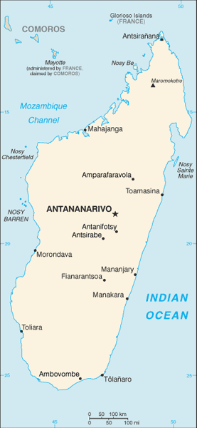
Country of Focus: Madagascar

Madagascar is the world’s fourth largest island with a total area of 226,657 square miles (“Madagascar Overview,” 2011). It is located in the Indian Ocean on the southeastern coast of Africa and separated from the coast by the Mozambique Channel. It claims four small islands located within the channel: the Iles Glorieuses, Bassas da India, Juan de Nova, and Europa (“Madagascar Overview,”2011). The capital, Antananarivo, is located close to the island’s center. The island consists mainly of a block of crystalline rocks. It is described as a plateau rising from the eastern narrow plain and descending in steps to strips of sedimentary rocks in the west (“Madagascar Overview,” 2011). The major rivers in this country flow westward; there are 100 miles of navigable rivers. The climate is moderated by altitude; the coast is hotter and wetter than the plateau. Southeasterly trade winds bring heavy rains in May through September to the eastern and northwestern coasts; the central plateau and western coast are blocked from the trade winds but receive rain from monsoon winds in October through April (“Madagascar Overview,” 2011). The southern area receives little rain and is somewhat of a desert. The population was approximately 17,404,000 in 2003; about 45% of the population was under the age of 15, and only 3% was over the age of 65 (“Madagascar Overview,” 2011). For every 100 females in the country, there were 99 males, so the sexes are pretty well balanced. The population density was 75 people per square mile in 2002 with the country’s western portion being the least dense (“Madagascar Overview,” 2011). About 20% of the country is covered by forest; round wood is removed and in 2000, all but 1% of it was used for fuel (“Madagascar Overview,” 2011). Medical services are free in this country; Malaria is one of the most major health problems, along with Tuberculosis.
References:
Africa. (2011). Encyclopedia of the Nations. Retrieved from http://www.nationsencyclopedia.com/Africa/index.html
Ituri forest landscape. (n.d.). Retrieved from http://carpe.umd.edu/resources/Documents/CL11_Ituri_SOF.pdf
Madagascar overview. (2011). Encyclopedia of the Nations. Retrieved from http://www.nationsencyclopedia.com/Africa/Madagascar.html
Pulsipher, L.M., & Pulsipher, A. (2008). World regional geography: global patterns, local lives (4th ed.).
New York, NY: W.H. Freeman and Company.
South africa gold. (2009). Maps of World. Retrieved from http://www.mapsofworld.com/south-africa/economy/gold.html
The kalahari: facts & info. (n.d.). Rhino Africa Safaris. Retrieved from http://www.rhinoafrica.com/botswana/the-kalahari/facts-and-information
The University of Texas at Austin. University of Texas Libraries: Perry-Castaneda Library Map Collection. Africa reference map,2003. Retrieved from http://www.lib.utexas.edu/maps/africa/africa_ref_2003.jpg
The University of Texas at Austin. University of Texas Libraries: Perry-Castaneda Library Map Collection. Madagascar small map, 2010. Retrieved from http://www.lib.utexas.edu/maps/cia10/madagascar_sm_2010.gif
ThinkQuest team. (1998). The land. The Living Africa. Retrieved from http://library.thinkquest.org/16645/the_land/the_land.shtml
