SOUTHEAST ASIA

Countries Present in this Region: 11
Burma (Myanmar), Thailand, Laos, Cambodia, Vietnam, Malaysia, Singapore, Brunei, Indonesia, Philippines, Timor-Leste
Physical Features:
The Barisan Mountains parallel the western coast of the Sumatra island of Indonesia. This is a volcanic mountain range that is approximately 1,000 feet long, starting at Aceh on the western tip of Sumatra and ending at Lampung at the bottom (“Barison,” 2008). It rises to Mt. Kerinci which is 12,467 feet in elevation (“Barison,” 2008). There are many lakes found within the mountains including Toba, Indonesia’s largest lake (“Barison,” 2008). This continuous mountain chain guards the province of the west side; this provides a home for thick, tropical jungles and lush vegetation (“Indonesia Fast Facts,” 2011). One can also find beaches, mountain streams, strong rivers, and gorgeous waterfalls here.
The Bago Mountains are located in south-central Burma. This mountain range extends 270 miles north to south between the Irrawaddy and Sittang rivers and ends in a ridge at Rangoon (“Bago Mountains,” 2011). The elevation averages about 2,000 feet in elation; the highest point is in the north, Popa Hill, at 4,981 feet in elevation (“Bago Mountains,” 2011). This highest point is an extinct volcano. In the eastern Bago Mountains, teak and other tropical hardwoods are extracted (“Bago Mountains,” 2011). The “hill peoples” or ethnic minorities practice shifting agriculture in this mountain range; they grow upland rice, corn, and millet (“Bago Mountains,” 2011).
The Gulf of Thailand is a semi-extension of the South China Sea. This gulf lies between Malay Peninsula and Thailand, Cambodia, and Vietnam. It is approximately 124,000 square miles and the deepest depth is 262 feet (“Gulf of Thailand”). The rather shallow waters are fed by fresh water inflow from the Chao Phraya River, giving the surface water a low salt concentration (“Gulf of Thailand”). The salt water inflow from the South China Sea enters in waters deeper than 160 feet (“Gulf of Thailand”). Because the water is warm, coral reefs thrive and the good dive sites provide a strong tourist industry. This gulf has offshore natural gas and some oil deposits (“Gulf of Thailand”).
The Strait of Malacca links the Indian Ocean with the Pacific Ocean via the South China Sea. It runs between Indonesia’s Sumatra Island, the Malay Peninsula, and Malaysia (“Strait of Malacca,” 2011). It has an area of approximately 25,000 square miles and is 500 miles long with widths from 40 to 155 miles (“Strait of Malacca,” 2011). The water current flows northwesterly through the strait all year long. This strait’s climate has both the northeastern monsoon during the winter and southwestern monsoon during the summer. Precipitation varies between 76 inches to 101 inches (“Strait of Malacca,” 2011). This is one of the busiest waterways in the world as it is the shortest sea route between India and China; approximately 140 ships pass through it every day (“Strait of Malacca,” n.d.). The cargo that passes through includes about 25% of the world’s oil; it comes from the Persian Gulf and is heading towards markets in Japan and China (“Strait of Malacca,” n.d.). Because of the high levels of traffic, piracy had dramatically increased. In 2004, 70 of the 251 pirate attacks happened in this area (“Strait of Malacca,” n.d.).
The Mekong River is a major river in southeastern Asia. It is the region’s longest river, flowing a distance of 4,200 miles (“Mekong River Valley,” 2000). It’s source is in China near the border with Tibet. It generally flows southeast going through the countries of China, Burma, Thailand, Laos, Cambodia, and Vietnam before ending in the South China Sea (“Mekong River Valley,” 2000). This river forms the border between Burma and Laos, along with most of the border between Laos and Thailand (“Mekong River Valley,” 2000). In the upper course of the river, there are steep descents and swift rapids; however, the river is navigable south of Laos (“Mekong River Valley,” 2000). The uses of this river include: irrigation, fisheries, power generation, transportation, industrial supply, and domestic supply (“Mekong River Valley,” 2000).
Climate:
Southeast Asia has a tropical climate with constant warm temperatures above 65°F and heavy rain in the lowlands (Pulsipher & Pulsipher, 2008). Rainfall results from the monsoons and the intertropical convergence zone (Pulsipher & Pulsipher, 2008). Monsoons are seasonal shifting winds and the ITCZ is the warm air band circling around the equator (Pulsipher & Pulsipher, 2008). From May to October, moist air from the surrounding seas is sucked into the warming Eurasian landmass and results in the wet summer season (Pulsipher & Pulsipher, 2008). A long dry season on the mainland, from November to April, happens when Eurasia has seasonal cooling and promotes dry air to flow out toward the sea (Pulsipher & Pulsipher, 2008). Winter can be wet on the islands as the continental air picks up moisture from the seas as it passes south and east; the islands of Southeast Asia are one of the world’s wettest areas (Pulsipher & Pulsipher, 2008). The El Nino phenomenon causes the normal rainfall patterns to be interrupted every 2-7 years. The patterns of air and water circulation in the Pacific are reversed when the El Nino comes about and a few changes take place.(Pulsipher & Pulsipher, 2008). In the western Pacific, ocean temperatures are cooler than normal. Cool, dry air sits on the surface of the ocean instead of the warm, wet air rising and making rainfall. This results in severe drought, which isn’t pleasurable for farmers.
Resources:
Throughout the region, different countries are rich in different natural resources ranging from hardwoods and minerals to oil. Burma is rich in natural resources including teakwood, oil, natural gas, tin, zinc, copper, marble, gemstones, and many others (Pulsipher & Pulsipher, 2008). In Burma’s interior uplands, up to 80% of the world’s remaining teakwood still grows; one single tree can be worth as much as $200,000 U.S. dollars (Pulsipher & Pulsipher, 2008).Cambodia has few viable mineral resources; in western Cambodia, there is a surplus of high-quality gems such as sapphires and rubies (“Asia and the Pacific,” 2011). Laos has an abundant supply of minerals such as gypsum which is exported to Vietnam; tin, coal, lignite, and limestone are also mined and their extensive tropical forests contain many valuable hardwoods such as teak (“Asia and the Pacific,” 2011). Vietnam has mineral resources of phosphate, coal, manganese, and offshore oil (Pulsipher & Pulsipher, 2008). They once had much forest cover; however, the Vietnam War destroyed much of it. Thailand discovered a natural gas field in the Gulf of Thailand with an oil production reaching almost 2,500 barrels per day (“Asia and the Pacific,” 2011). The backbone of Brunei’s economy is oil and natural gas mining; it is the third largest oil producer in Southeast Asia and the fourteenth largest in the world (“Asia and the Pacific,” 2011). It also ranks fourth in natural gas production (“Asia and the Pacific,” 2011). Indonesia has important minerals and metals including tin, nickel, copper, gold, silver, and coal; Papua has the world’s largest copper and gold mine (“Asia and the Pacific,” 2011). The Philippines have a rich deposit of gold, copper, iron, and chromate (Pulsipher & Pulsipher, 2008).
Environmental Issues:
Southeast Asia suffers from deforestation, mining, and air pollution. This region has the second highest deforestation rate; they are right behind sub-Saharan Africa (Pulsipher & Pulsipher, 2008). Estimates show that 13-19 square miles of rainforests are destroyed daily; this is 50% faster than in the Amazon (Pulsipher & Pulsipher, 2008). Illegal logging happens faster than legal logging in this region. The impact of illegal logging on the environment is worse because it is done fast and secretly, along with using heavy equipment without worrying about preserving the natural habitat (Pulsipher & Pulsipher, 2008). Much of the deforestation is linked to population growth and poverty. Because of the fast population growth recently, cultivation is expanding and resulting in erosion. Without the forests to cover the land, water moves across the land before it can be absorbed; this takes away the topsoil that is already thin in tropical environments (Pulsipher & Pulsipher, 2008). In the Philippines, logging for timber is the main cause of deforestation, right along with commercial agriculture. Another issue is mining. In Southeast Asia, a process known as mechanical strip-mining is used to extract minerals such as copper, silver, and gold (Pulsipher & Pulsipher, 2008). With this process, the forest cover is cleared and the layers of soil and rocks that cover the minerals are stripped away by heavy equipment (Pulsipher & Pulsipher, 2008). Unlike the United States, this region doesn’t have any environmental regulations that require mining companies to rehabilitate the lands that they stripped; this is a reason why international mining companies are so interested in the region (Pulsipher & Pulsipher, 2008). The most publicized mine is the “Mine in the Clouds” located in West Papua. It is said that mining will continue for at least another century. Local villagers are complaining that they are being driven off of their land without getting any money; others are saying that the tailings from the mine are polluting the Aikwa River (Pulsipher & Pulsipher, 2008). The other issue in this region is air pollution. Southeast Asia’s islands have been regularly covered with a cloud of pollution since the 1990s (Pulsipher & Pulsipher, 2008). Air pollution is worse in large cities such as Kuala Lumpur and Jakarta. People are encouraged to wear masks and airplanes cannot land on days when air pollution is at its worst (Pulsipher & Pulsipher, 2008). Smoke from logged forestland fires to prepare for oil palm tree and luceana planting is the main cause of the poisonous cloud of smoke. The unfavorable winds and the dryness combine to spread the fires and also prevent it from escaping into the atmosphere (Pulsipher & Pulsipher, 2008). The normal industrial pollution in the region also contributes to this air pollution.
Population Patterns:
A group of hunters and gatherers, known as Australo-Melanesians, were one of the first groups of people to settle in Southeast Asia. This group, from India and Burman, migrated about 40,000 to 60,000 years ago and were New Guinea, Australia, and Indonesia’s indigenous people’s ancestors (Pulsipher & Pulsipher, 2008). About 10,000 years ago at the end of the ice age, people from southern China started migrating into Southeast Asia; this was the second migration (Pulsipher & Pulsipher, 2008). This “migration gained momentum as a result of a culture of skilled farmers and seafarers from Southern China;” this group of people were known as Austronesians (Pulsipher & Pulsipher, 2008). They migrated first to Taiwan, and then went on to the Philippines and islands of Southeast Asia. This region has a diverse culture; there are a variety of both internal and external cultural influences. The surrounding seas and climate brought seaborne traders, religious teachers, and a few invading armies from India and Arabia’s coasts (Pulsipher & Pulsipher, 2008). These people brought Hinduism, Buddhism, Islam, and Christianity with them, along with trade goods and food plants (Pulsipher & Pulsipher, 2008). They went as far as Cambodia, Laos, Vietnam, and China; they also reached islands farther south (Pulsipher & Pulsipher, 2008). Internal cultural influences, including indigenous cultural characteristics have played a role in the region. Many powerful urban empires came about between 600 and 1400 (Pulsipher & Pulsipher, 2008). Many European countries have established colonies within the region in the last five centuries. In 1511, the first European settlement occurred as a result of the Portuguese being drawn into the region by the spice trade; this settlement occurred on the Malay Peninsula (Pulsipher & Pulsipher, 2008). The Spanish had formed trade links across the Pacific by 1540. They ruled the Philippines for more than 350 years and had much domination (Pulsipher & Pulsipher, 2008). The Dutch, who controlled trade over Indonesia, were very economically successful compared to the rest of the European colonial powers in the region (Pulsipher & Pulsipher, 2008).They became interested in growing cash crops to export. They diverted farmers who grew their own food to working part time in Dutch enterprises without pay between 1830 and 1870 (Pulsipher & Pulsipher, 2008). This disrupted the local food production system and resulted in famines and the hastening spread of Islam throughout Indonesia (Pulsipher & Pulsipher, 2008). British colonizers controlled important ports of the Malay Peninsula; they held these ports for trade value and protecting the passage of sea trade between China and Britain’s empire located within India (Pulsipher & Pulsipher, 2008). Britain then extended its rule and took the rest of Malaysia, thus adding Burma to its empire. They were able to control access to forest resources and overland trade routes to China (Pulsipher & Pulsipher, 2008). In the early seventeenth century, the French came to the region as Catholic missionaries. The French later colonized this area for greater access to nearby China markets. The only country not to be colonized within the region was Thailand (Pulsipher & Pulsipher, 2008). Because fighting for independence was a struggle, many countries didn’t gain independence until after World War II (Pulsipher & Pulsipher, 2008). Colonial powers granted self-government to most of the region by the mid-1950’s. French-controlled territories, areas of Vietnam, Laos, and Cambodia, had the worst battle for independence (Pulsipher & Pulsipher, 2008). Although they became nominally independent in 1949, France still held political and economic power. The cold war was brought about within the region and the French were defeated in 1954 (Pulsipher & Pulsipher, 2008). The United States stepped in as they were worried about the spread of international Communism; they ended up withdrawing because of U.S. public opinion in 1973 (Pulsipher & Pulsipher, 2008). A new national government was established in 1975 when the war ended as a result of the North defeating the South (Pulsipher & Pulsipher, 2008).
More than half a billion people live on South Asia’s islands and peninsulas; two times more people live on half as much land compared to the United States (Pulsipher & Pulsipher, 2008). Very few people live in upland Burma, Thailand, Laos, and Cambodia due to the rugged land. Because wetlands, heavy forests, and mountains cover parts of Malaysia, Indonesia, and the Philippines, the areas of lightly settled (Pulsipher & Pulsipher, 2008).Over the last couple of decades, areas of light settlements have gained thousands of new people because of promises of farmland and jobs in both commercial agriculture and forest products /mineral extractions (Pulsipher & Pulsipher, 2008). About 60% of the population lives in dense rural settlements along the coastlines, floodplains of major rivers, and mainland river deltas. The most concentrated settlements on the islands are Luzon in the northern Philippines and Java because of the rich and moist soils that allow good agriculture (Pulsipher & Pulsipher, 2008). Approximately 38% of people live in cities and a majority of the medium-sized cities are the “most rapidly growing metropolitan areas on earth (Pulsipher & Pulsipher, 2008). Smaller families are common in Southeast Asia. Fertility rates are decreasing; Singapore and Thailand have the lowest fertility rates in the region (Pulsipher & Pulsipher, 2008). Cambodia and Laos are very poor countries; however, they have high fertility rates. This region has a young population with 30% of the population being 15 or younger (Pulsipher & Pulsipher, 2008). HIV-AIDS is a large public health issue in the region as infection rates are growing; Cambodia, Thailand, Burma, and parts of Indonesia have the highest rates (Pulsipher & Pulsipher, 2008).
Role of Gender:
Generally, men have jobs in agriculture and manufacturing; there is a rise of employment in the service industry also (Pulsipher & Pulsipher, 2008). Throughout the region, men have a higher rate of paid employment. Many women do work in the home, in the formal economy, and also in traditional agriculture (Pulsipher & Pulsipher, 2008). When women work in the formal economy, they earn only a half of what men do on average (Pulsipher & Pulsipher, 2008). However, in Burma, Cambodia, and Vietnam, women make only 1/3 less than men (Pulsipher & Pulsipher, 2008). More women than men are completing extra training after secondary school in Brunei, Burma, Malaysia, the Philippines, and Thailand; this gives women an advantage for future employment in industries within Southeast Asia (Pulsipher & Pulsipher, 2008). For example, education is an advantage in information technology industries.
It is common for newly married couples to live with the woman’s parents. Families are headed by the oldest male which is generally the woman’s father. If he dies, he passes his wealth and power to the oldest daughter’s husband instead of his own son (Pulsipher & Pulsipher, 2008). “A husband may live for many years as a subordinate in his father-in-law’s home (Pulsipher & Pulsipher, 2008). Young couples in urban families often live away from the extended family to take pressure off the husband in daily life (Pulsipher & Pulsipher, 2008). Because this is a nuclear family life, the wives usually work outside of the home for money because they are dependent on themselves for support (Pulsipher & Pulsipher, 2008).
Religions:
Hinduism, Buddhism, Confucianism and Taoism, Islam, Christianity, and animism are among the major religious traditions in the region (Pulsipher & Pulsipher, 2008). Each religion, except for animism, originated outside of the region and was primarily brought by traders, priests, and colonists. Animist belief systems were of the indigenous peoples (Pulsipher & Pulsipher, 2008). With the Animist belief system, natural features (trees, rivers, vegetation, rainfall) have spiritual meaning; these are the focus of the festivals and rituals that take place to give thanks for bounty and to mark the passing of the seasons (Pulsipher & Pulsipher, 2008). The patterns of the religions, except for animism, were of inland and mainland divisions. Buddhism is popular in Burma, Thailand, and Cambodia (Pulsipher & Pulsipher, 2008). A mix of Buddhist, Confucian, and Taoist beliefs that originated in China are practiced in Vietnam (Pulsipher & Pulsipher, 2008). Indonesia, the world’s largest Muslim country, has a dominant religion of Islam (Pulsipher & Pulsipher, 2008). Islam is also practiced on the Malay Peninsula and in Malaysia; the religion is growing in the southern Philippines (Pulsipher & Pulsipher, 2008). Portuguese and Spanish colonists introduced the predominant religion of Roman Catholicism in both Timor-Leste and the Philippines (Pulsipher & Pulsipher, 2008). Hinduism in only found in small patches on the Bali and Lombok islands; however, it was once more widespread when it arrived thousands of years ago with Indian traders (Pulsipher & Pulsipher, 2008). Hinduism was reintroduced in minority communities in Burma, Malaysia, and Singapore by Indian immigrant laborers in the twentieth century (Pulsipher & Pulsipher, 2008). Because the religions have been exposed to each other, the region’s religions have undergone change. The majority of Muslims and Christians believe it spirits; they also practice rituals that have animism roots (Pulsipher & Pulsipher, 2008). In Indonesia, Hindus and Christians have absorbed ideas such as the seclusion of women from Islam as they are surrounded by Muslims (Pulsipher & Pulsipher, 2008) Muslims have absorbed indigenous belief system ideas and customs such as kinship and marriage ideas (Pulsipher & Pulsipher, 2008).
Transportation:
Transportation varies throughout the region; most transportation is done by roadways and air travel. Brunei has a well developed infrastructure. There are over 1,500 miles of roadways and a 715 mile highway that runs the length of the entire coastline (“Asia and the Pacific,” 2011). There are no rail services other than a 8 mile private railway. This country has one of the world’s highest per capita car ownerships (“Asia and the Pacific,” 2011). Burma has inadequate infrastructure including roads, bridges, canals, railways, and ports. The some 17,500 miles of roadway are in poor condition and much of them are not passable during the monsoon season (“Asia and the Pacific,” 2011). Cambodia has a weak infrastructure due to the many civil wars. They have a limited train system and only 11.6% of the 22,227 miles of highway are paved (“Asia and the Pacific,” 2011). Travel to remote provinces is done by plane. There are approximately 2,300 miles of navigable waterways also (“Asia and the Pacific,” 2011). Indonesia has effective infrastructure, especially roads. There are 212, 954 miles of roads, 4,013 miles of railways, and 16 million vehicles on the road (“Asia and the Pacific,” 2011). All but 2.6 million of these vehicles were motorcycles. Because Indonesia is an archipelago, they rely heaving of fleets of ships for transporting both goods and passengers (“Asia and the Pacific,” 2011). Laos has a weak physical infrastructure as there are no train systems, travel to remote provinces requires a plane, and roads many be impassable during the rainy season (“Asia and the Pacific,” 2011). Inexpensive bus transportation, however, is available to travel through the country. Malaysia has well-developed but uneven distribution of transportation networks. This country has a total of 44,100 miles of primary and secondary roads with 360 miles of included good quality expressways, and 1,120 miles of railway. In 1996, there were 7 million registered vehicles in Malaysia including more motorcycles and mopeds than passenger cars (“Asia and the Pacific,” 2011). The Philippines have 306 miles of railroads, 124,249 miles of roads, and 1,490 ports that connect its major islands. Manila, the busiest national port, has 90% of the country’s imports and 20% of its export pass through it (“Asia and the Pacific,” 2011). Singapore has a well-developed transport network and a superior infrastructure inherited from the colonial era. Over 99% of the 1,940 miles of the highways are paved (“Asia and the Pacific,” 2011). Thailand has an inadequate transportation infrastructure. Vietnam has a weak infrastructure but it is steadily improving. In this country, travel to distant remove provinces is done by air (“Asia and the Pacific,” 2011).
Agriculture:
Agriculture’s impact on the economy has been declining over the years and amounts to less than 1/6th of the region’s total GDP (Pulsipher & Pulsipher, 2008). All but 40% of this region’s population relies on agriculture for some of their support. Commercial agriculture is important for both exports and parts of urban diets. Exports include rice, sugar, coconut products, rubber, and palm oil; urban diet components include rice, fish, meat, dairy products, and fruits & vegetables (Pulsipher & Pulsipher, 2008). There are several forms of agriculture used throughout this region. Where population densities are fairly low, shifting cultivation is practiced by farmers providing for their families; these areas include the mainland Southeast Asia and the southern Philippines, among other areas (Pulsipher & Pulsipher, 2008). Because farmers are moving their fields about every 3 years to more fertile soils, larger than normal areas are needed to support human populations. Wet rice cultivation is the most productive type of agriculture as it is permanent and doesn’t shift (Pulsipher & Pulsipher, 2008). Rice seedlings are planted in cultivated, flooded terraced fields. This is generally practiced where streams bring in rich silt and on rich volcanic soils (Pulsipher & Pulsipher, 2008). Small farms have been transformed into large commercial farms owned by corporations. They produce cash crops to export such as bananas, pineapples, rubber, and palm oil, among many others (Pulsipher & Pulsipher, 2008). The need of this agriculture includes having to clear-cut forests, deep plow the soil, and using mechanized equipment. The objective to commercial farming is that it is a quick profit with a reduction in the need for labor (Pulsipher & Pulsipher, 2008). Southeast Asia’s soil is not very fertile; however, they support a variety of vegetation. Rapid decay of dead organic material happens because of the warm, damp conditions (Pulsipher & Pulsipher, 2008). The living forests soak up the useful minerals released from the decay of dead organic material instead of enriching the soil (Pulsipher & Pulsipher, 2008).

The Philippines are made up of more than 7,000 islands and are located on the eastern rim of Asia. This country is bordered on the east by the Philippine Sea, the west by the South China Sea, the north by the Luzon Strait, and the south by the Celebes Sea (“Asia and the Pacific,” 2011). These islands spread over approximately 500,000 square miles of ocean; the total land area is estimated at 116,000 square miles (“Asia and the Pacific,” 2011). Together, the two largest islands of Luzon in the north and Mindanao in the south make up almost 2/3 of the total land area (Pulsipher & Pulsipher, 2008). The Philippine Islands are part of the Pacific Ring of Fire; volcanic eruptions over time have given the country fertile soil and rich mineral deposits (Pulsipher & Pulsipher, 2008). The population has more than tripled since 1948 with an estimated population of 81.2 million people in 2000 (“Asia and the Pacific,” 2011). The country’s capital, Manila, has a population of almost 18 million people; this is the one of the world’s largest and most densely settled urban areas (Pulsipher & Pulsipher, 2008). Many people living in the cities are unemployed and they live in shelters made out of scraps. Almost 96% of the population is of indigenous minority and has at least 60 different ethnic groups (Pulsipher & Pulsipher, 2008). The Philippines transport infrastructure includes 306 miles of railroads and 124,000 miles of roads. The islands of the Philippines have more than 1,490 ports that connect its major islands. In Manila, the busiest national port receives 90% of the country’s imports and more than 20% of its exports leave this port (“Asia and the Pacific,” 2011). This country has been recognized as “the global capital for text messaging” (“Asia and the Pacific,” 2011). It is a primary agricultural country; most citizens live in rural areas and support themselves through agriculture. The main crops include rice, corn, coffee, tobacco, sugarcane, coc0nut, bananas, and mangoes (“Asia and the Pacific.” 2011).
References:
Asia and the pacific. (2011). Encyclopedia of the Nations. Retrieved from http://www.nationsencyclopedia.com/economies/Asia-and-the-Pacific/index.html
Bago mountains. (2011). Encyclopaedia Britannica. Retrieved from http://www.britannica.com/EBchecked/topic/448796/Bago-Mountains
Barison. (2008). The Columbia Encyclopedia, Sixth Edition. Retrieved from http://www.encyclopedia.com/topic/Barisan.aspx#1
Gulf of thailand. (n.d.). Retrieved from http://na.oceana.org/en/explore/places/gulf-of-thailand
Indonesia fast facts. (2011, March 11). Retrieved from http://www.imaginationsinc.org/indonesia-fast-facts.htm
Mekon river valley. (2000). Retrieved from http://www.africanwater.org/mekong_river.htm
Pulsipher, L.M., & Pulsipher, A. (2008). World regional geography: global patterns, local lives (4th ed.).
New York, NY: W.H. Freeman and Company.
Strait of malacca. (2011). Encyclopaedia Britannica. Retrieved from http://www.britannica.com/EBchecked/topic/359411/Strait-of-Malacca
Strait of malacca. (n.d.). Retrieved from http://na.oceana.org/en/explore/places/strait-of-malacca
The University of Texas at Austin. University of Texas Libraries: Perry-Castaneda Library Map Collection. Philippines small map,2010. Retrieved from http://www.lib.utexas.edu/maps/cia10/philippines_sm_2010.gif
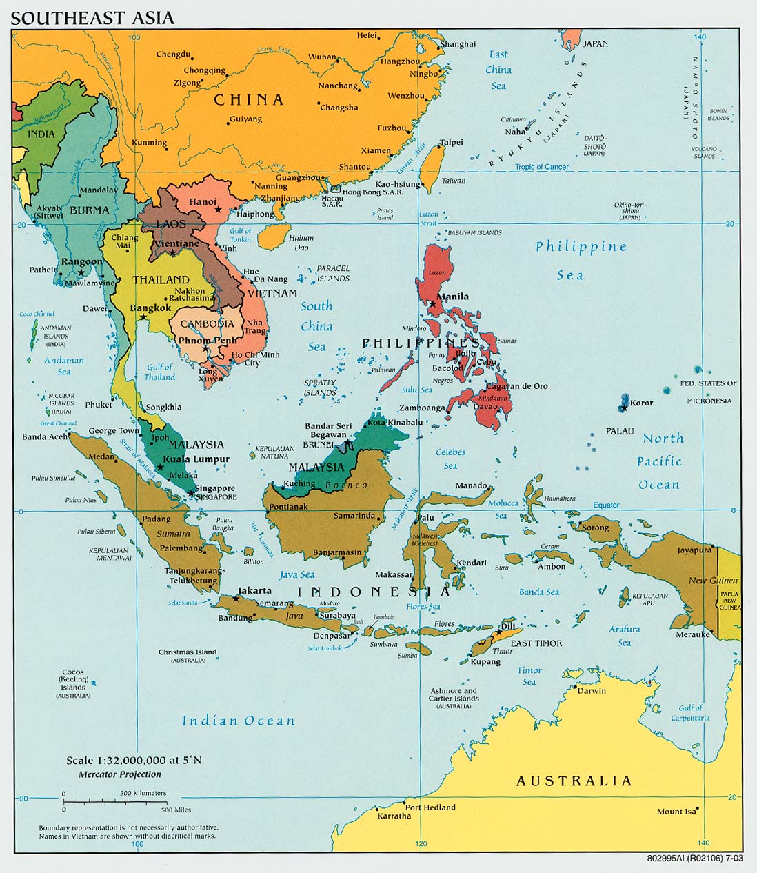
The University of Texas at Austin. University of Texas Libraries: Perry-Castaneda Library Map Collection. Southeast asia political map, 2003. Retrieved from http://www.lib.utexas.edu/maps/middle_east_and_asia/southeast_asia_pol_2003.jpg
References:
Asia and the pacific. (2011). Encyclopedia of the Nations. Retrieved from http://www.nationsencyclopedia.com/economies/Asia-and-the-Pacific/index.html
Bago mountains. (2011). Encyclopaedia Britannica. Retrieved from http://www.britannica.com/EBchecked/topic/448796/Bago-Mountains
Barison. (2008). The Columbia Encyclopedia, Sixth Edition. Retrieved from http://www.encyclopedia.com/topic/Barisan.aspx#1
Gulf of thailand. (n.d.). Retrieved from http://na.oceana.org/en/explore/places/gulf-of-thailand
Indonesia fast facts. (2011, March 11). Retrieved from http://www.imaginationsinc.org/indonesia-fast-facts.htm
Mekon river valley. (2000). Retrieved from http://www.africanwater.org/mekong_river.htm
Pulsipher, L.M., & Pulsipher, A. (2008). World regional geography: global patterns, local lives (4th ed.).
New York, NY: W.H. Freeman and Company.
Strait of malacca. (2011). Encyclopaedia Britannica. Retrieved from http://www.britannica.com/EBchecked/topic/359411/Strait-of-Malacca
Strait of malacca. (n.d.). Retrieved from http://na.oceana.org/en/explore/places/strait-of-malacca
The University of Texas at Austin. University of Texas Libraries: Perry-Castaneda Library Map Collection. Philippines small map,2010. Retrieved from http://www.lib.utexas.edu/maps/cia10/philippines_sm_2010.gif
The University of Texas at Austin. University of Texas Libraries: Perry-Castaneda Library Map Collection. Southeast asia political map, 2003. Retrieved from http://www.lib.utexas.edu/maps/middle_east_and_asia/southeast_asia_pol_2003.jpg
