SOUTH ASIA

Countries Present in this Region: 8
Afghanistan, Pakistan, India, Nepal, Bhutan, Bangladesh, Sri Lanka, Maldives
Physical Features:
The Indus River starts high southwestern China, in the mountains of Tibet, and flows northwest through the Jammu and Kashmir region of India and Pakistan, south through Pakistan, and ends in the Arabian Sea. It is one of the world’s longest rivers, with a length of 1,800 miles (“Major Rivers”). Through a series of dams and canals, this river provides much of central Pakistan’s irrigation and power (“Major Rivers”). The lower Indus River is navigable for small boats; however, it is rarely used for transportation ever since the development of railroads. Because of the extensive use of Indus’s water for irrigation, the flow of freshwater in the lower Indus has been greatly reduced. This reduced flow of water has led to the encroachment of saltwater and the loss of millions of acres of surrounding farmland.
The Palk Strait lies between Indian and Sri Lanka and is 40 to 85 miles wide (“Palk Strait,” 2008). The southern end of the strait is studded with shoal reefs in which form Adam’s Bridge. This bridge, at high tide, is covered by 4 feet of water; this forces oceangoing vessels to travel around Sri Lanka instead of going through the Palk Strait (“Palk Strait,” 2008). Also at the southern end, lie small islands. Because of the treacherous waters of the strait, most ships avoid it.
The Thar Desert is located in northwestern India with a total area of 16,907 square miles (“Thar Desert,” 2008). It is the world’s seventh largest deserts and also the most unfriendly and inhospitable ecoregions around the region. This desert is very arid and has an extreme climate; the annual temperatures range from almost freezing in the winter to over 122°F in the summer (“Thar Desert,” 2008). The July-September monsoon brings between 4-20 inches of rain per year (“Thar Desert,” 2008). Only 10% of the desert is covered in sand dunes; the rest is covered in such things as rock forms (“Thar Desert,” 2008). It is the world’s most densely populated desert; livestock (sheep and goat) grazing is intensive and affects the fertility of the soil and destroys native vegetation.
The Himalayas are a mountain range in Asia forming a barrier between the Tibetan Plateau and the plains of India in the south. The majority of the mountain range runs along the northern portion of India and China. They span 1,550 miles from the west at the Jammu and Kashmir territory all the way to China’s southern border with India (“The Himalayas”). The Himalayas were formed as a result of the continued southward pushing, leading India’s north edge and Eurasia’s south edge to crumple and buckle (Pulsipher & Pulsipher, 2008). This mountain range has 30 mountains, rising more than 28,000 feet making them the world’s highest mountains (Pulsipher & Pulsipher, 2008). The world’s highest peak, Mt. Everest, rises 29,029 feet above sea level (“The Himalayas”). The mountain ranges have steep-sided jagged peaks that are snow capped, enormous valley glaciers, deep river gorges, and rich vegetation. The resources included in this region include “rich arable land, extensive grassland and forest, mineral deposits, and a tremendous potential for hydroelectric power that can be harnessed easily” (“The Himalayas”).
The Western Ghats “stretch out like a mountainous spine” approximately 870 miles from north to south (“Introducing the Western Ghats,” 2009). They peter out at the southernmost tip of Tami Nadu. The hills’ average elevation is about 570 miles; they are covered with evergreen and deciduous forest (“Introducing the Western Ghats”). The Western Ghats are the source of all South India’s major rivers. They have 27% of all India’s flowering plants, 60% of medicinal plants, and much endemic wildlife (“Introducing the Western Ghats”). Several tribal groups live within, although their traditional lifestyles are being eroded fast.
Climate:
Wind patterns affect the climate in South Asia; these dominant wind patterns are called monsoons. In the winter months, cool and dry air moves from the center of the continent towards the Indian Ocean (Pulsipher & Pulsipher, 2008). In the summer months, warm and wet air travels from the Indian Ocean and brings large amounts of rainfall (Pulsipher & Pulsipher, 2008). These large amounts of rainfall are also caused by the intertropical convergence zone (ITCZ) in which air from the north and south meet, rises and cools, and then produces precipitation (Pulsipher & Pulsipher, 2008). A big influence on the climate is the region’s monsoons. The warm, moist ITCZ air reaches the mountainous area of the Western Ghats in the first part of June; as it moves over the mountains, the air cools and releases rainfall to nurture tropical rain forests and crops in the central uplands (Pulsipher & Pulsipher, 2008). As the summer monsoon gains moisture and power on its northward journey, the rising warm air creates very large thunderclouds that dump rain on the dry countryside. Near the Bay of Bengal, the monsoons may turn into tropical cyclones (Pulsipher & Pulsipher, 2008). Even though the Himalayan foothills only have rain half of the year, they have the world record of rainfall of 35 feet per year (Pulsipher & Pulsipher, 2008). Running in bands parallel to Himalayas, monsoon rains stretch across northern India and reach northern Pakistan by July. Because of these patterns of rainfall, the climate zones vary. Cooler and drier air is sent over South Asia because of the cooling Eurasian landmass by November (Pulsipher & Pulsipher, 2008). The northern heavy air pushes the warm, wet air back to the Indian Ocean resulting in little rainfall during the winter monsoon. However, areas in southeastern India and Sri Lanka may receive winter rains (Pulsipher & Pulsipher, 2008).
Resources:
South Asia has an abundance of natural resources; however, the resources uneven distribution affects the region’s balanced development. India has the majority of the region’s total natural resources; they account for 70% of them (Basnyat, 2008). Water resources are derived in bulk from common rivers flowing through more than one country. The use of large water resources of the Himalayas helps meet critical shortages of irrigation water and power supplies, along with flood control effort with help and cooperation with other South Asian countries (Basnyat, 2008). Bangladesh has adequate gas reserves and has the opportunity to trade gas with Bhutan, India, and Nepal. India is rich in coal reserves; if they were to manage this resource right, they could meet the rising demand for power in South Asian countries (Basnyat, 2008). Firewood is used for cooking and heating in South Asian countries; however, forest lands cover less than 2% of the world’s total leading to a shortage of timber and forest resources (Basnyat, 2008). South Asia has poor fuel resources (oil and gas) and has to depend on imports from other parts of the world. Possible exploitation of potential resources could lead to possessing less than one percent of the world’s total gold, copper, silver, lead, diamond, and zinc (Basnyat, 2008). Evidence states that the Himalayas are rich in some mineral resources, but they haven’t been explored or tapped. A major issue regarding South Asian natural resources management is “how to manage the land, forest, and water resources in order to maintain both their productive capacities and ecological functions” (Basnyat, 2008).
Environmental Issues:
The use of water in this region is a problem. This region has over 20% of the world’s population, but only has 4% of its fresh water (Pulsipher & Pulsipher, 2008). India has diverted 60% of the Ganga River’s flow to Kolkata during the dry season. Channels have silt accumulating; this is affecting river traffic. The water is to flush out the channels. India’s policies deprive Bangladesh of normal flow of fresh water (Pulsipher & Pulsipher, 2008). Deltas have less water; this means salt water from the Bay of Bengal can flow inland and ruin agricultural fields. The diversion damaged many small-scale fishing industries (Pulsipher & Pulsipher, 2008). The water purity of Ganga River is not so good. Pilgrimage towns, where Hindus come to die and be cremated, have their ashes spread over the Ganga River. Because firewood has become scarce for the cremation fires, bodies are not being fully cremated and are still being put in the river; this means instead of ashes, there are some body parts but into the river as well (Pulsipher & Pulsipher, 2008). This pollutes drinking, cooking, and bathing water. Along with the cremated ashes, industrial waste and sewage are being dumped into the river. Varanasi’s sewage system has exceeded its capacity and is dumping raw forms of sewage in the river (Pulsipher & Pulsipher, 2008). Another environmental issue is that industrial activity is endangering the air in many parts of the region. Vehicle and coal-burning power plant emissions are as bad as smoking 20 cigarettes a day in Delhis (Pulsipher & Pulsipher, 2008). Industries along the Yamuna and Ganga rivers are producing acid rain, thus destroying farmland and great monuments. M.C. Mehta, a lawyer and environmental activist, promoted environmental legislation to remove hundreds of factories on the river valleys that were polluting the air (Pulsipher & Pulsipher, 2008). These actions were also a response to a 1984 pesticide plant explosion in India that killed 3,000 people and destroyed the health of more than 50,000 people as it destroyed the lungs (Pulsipher & Pulsipher, 2008).
Population Patterns:
Evidence suggests that early humans were found in South Asia over 200,000 years ago; however, 38,000 years ago was the first evidence of modern humans (Pulsipher & Pulsipher, 2008). The Indus Valley Civilization, the first large settled agricultural communities, was established about 4,500 years ago. The Indus Valley civilization declined about 3,700 years ago, 800 years after it was established for unknown/debatable reasons (Pulsipher & Pulsipher, 2008). About 3,500 years ago, the Aryans, or the first recorded South Asia Invaders moved into the Indus Valley from Central and Southwest Asia (Pulsipher & Pulsipher, 2008). Arab traders and religious mystics came to the coasts of southwestern India and Sri Lanka about 1000 years ago and introduced Islam. The Mughals, Turkic Persian groups of people from Central Asia, invaded in 1526, thus spreading Islam (Pulsipher & Pulsipher, 2008). Many regional states and kingdoms grew in power and competed with one another after the last Mughal leader died in 1707 (Pulsipher & Pulsipher, 2008). A majority of South Asia was controlled by the British between the 1830s and 1947. The British policy was to use South Asia’s resources to benefit Britain. If there was any economic development taking place, it was only allowed if it benefited Britain. In the nineteenth century, many people were pushed out of their textile manufacturing jobs (Pulsipher & Pulsipher, 2008). Agricultural labor was already abundant, so many had to migrate to urban areas in search of work. Because many people couldn’t pay for taxes on their land, they lost their land to large business landowners (Pulsipher & Pulsipher, 2008). The British Empire brought in a railroad system that was used for within region trade. Not only did they bring this in, they brought in the English language making trade a whole lot easier. In 1947, British India was granted independence (Pulsipher & Pulsipher, 2008). Since then, South Asians have had both progress and setbacks; democracy steadily expanded but albeit slowly expanded. Relative prosperity was brought into rural areas as a result of agricultural advances. When it was decided that northwestern and northeastern India would become a single country, more than 4 million Hindus and Sikhs moved from Pakistan to India fearing that they would be persecuted if they didn’t move (Pulsipher & Pulsipher, 2008). Another 4 million Muslims left their homes in India and moved to Pakistan (Pulsipher & Pulsipher, 2008). In the process of the single country, many families and communities were dived, rape was widespread, and a million plus people were killed (Pulsipher & Pulsipher, 2008).
This region has a highly dense population; it is one of the most densely populated in the world (Pulsipher & Pulsipher, 2008). Only about 30% of the population lives in urban areas. South Asia already has a population of 1.44 billion, and the continuing rapid population growth puts problems onto the quality of life of people (Pulsipher & Pulsipher, 2008). Each year, India alone adds 18 million people to its ranks. Since 1952, they have been trying to reduce birth rates. The age of the population is very young as over a third of its people are under the age of 15 (Pulsipher & Pulsipher, 2008). Infant mortality rates average 67 per 1000 live births because of the limited health care access (Pulsipher & Pulsipher, 2008)
Role of Gender:
Women in this region generally have a lower status than that of men. Women have the lowest status and rank in a belt running from northwest Afghanistan, across Pakistan and western India, and into Bangladesh (Pulsipher & Pulsipher, 2008).Because of different marriage and inheritance practices in eastern, central, and southern India and Sri Lanka, women fare better here and also have greater access to education and resources(Pulsipher & Pulsipher, 2008). Women living in urban areas have more individual freedom than rural women. Women of middle and upper class are more restricted in their movements than those women in the lower classes. Lower class women, however, have to put up with sexual harassment and exploitation from upper class men (Pulsipher & Pulsipher, 2008). Young women have more educational and employment opportunities now compared to a generation ago; large numbers of young women are entering the skilled workforce. Muslim women have a lower socioeconomic status than Christians and Hindus (Pulsipher & Pulsipher, 2008).There is much violence throughout the region. In 2005, 7,026 deaths occurred resulting from bride burning. This is when a husband and his relatives start an accident or fire that kills his wife; this usually occurs in India (Pulsipher & Pulsipher, 2008). Women are concealed from the eyes of men that aren’t considered family; this is called purdah (Pulsipher & Pulsipher, 2008). This practice is to limit their economic independence and autonomy. Marriage partners for women are arranged for them, even if it is against their wishes. In some communities within the region, a death of a husband may deprive her of all support, her home, children, and even reputation (Pulsipher & Pulsipher, 2008). This alone shows how much power and significance men have compared to women. In some areas, baby girls are either killed or aborted because they aren’t affordable because of the dowry investment that is required of them (Pulsipher & Pulsipher, 2008).
Religions:
A variety of religions, including Hinduism, Buddhism, Sikhism, Jainism, Islam, and Christianity are practiced within this region. Approximately 900 million people world-wide practice Hinduism, with 800 million of them living in India (Pulsipher & Pulsipher, 2008). This belief system is very complex and makes it hard for outside people to understand. Many contradictions in this religion are found because there are a broad range of both beliefs and practices with derived roots from “highly localized folk traditions” and the classical Hindu system (Pulsipher & Pulsipher, 2008). These traditions are based on the Harappan and Aryan ritual beliefs amalgam in old Sanskrit texts. A classical Hindu philosophy states that “all gods are merely illusory manifestations of the ultimate divinity, which is formless and infinite” (Pulsipher & Pulsipher, 2008). Many Hindus do not worship any gods; instead they take part in meditation, yoga, or other spiritual practices that would bring them closer to reality. However, the average person needs the help of “personified divinities in the form of gods” (Pulsipher & Pulsipher, 2008). Hindus generally have class/group identities; classical Hindu rituals are intertwined in them, and they are differentiated by dietary rules. The majority of Hindus have a similar belief of reincarnation; an idea about any living thing that desires “illusory pleasures and pains of life” will be born again after it dies (Pulsipher & Pulsipher, 2008). Cows are very well respected as they are seen with a little less spirituality than humans; Hindus do not eat beef. Hindus are mostly found in India; the place of origin is the Ganga Plain (Pulsipher & Pulsipher, 2008). Buddhism was started over 2600 years ago as a “reform and reinterpretation of Hinduism” (Pulispher & Pulsipher, 2008). Northern India was the place of origin before it grew and spread to East and Southeast Asia. About 10 million people, or 1% of South Asia’s population, are Buddhists (Pulsipher & Pulsipher, 2008). These Buddhists are mainly in Bhutan and Sri Lanka. Like Hindus, Buddhists have a common belief of reincarnation, the idea that people are reborn after dying.
Followers of Islam (Muslims) make up about 420 million people in this region; they dominate Afghanistan, Pakistan, Bangladesh, and the Maldives. About 120 million Muslim people make up India, which is an important minority (Pulsipher & Pulsipher, 2008). About 18 million people follow Sikhism in northwestern India; this religion was inspired by Hindu and Islamic ideals (Pulsipher & Pulsipher, 2008). This religion’s influence on the region is large as many followers hold military and police positions. Jainism accounts for about 6 million people mainly in western India and throughout large urban centers within the region (Pulsipher & Pulsipher, 2008). These Jains are known for educational achievements, strict vegetarian diet, and nonviolence.
Transportation:
In this region, roadways, railways, waterways, and airways are the main modes of transportation. In Afghanistan, there are only 12,050 miles of total roadways and since 1993, the conditions of the roads have been deteriorating and bridges being destroyed; because of this, many remote mountain areas have been cut off (“Asia and the Pacific,” 2011). The aviation infrastructure was basically completely destroyed by the war; the majority of the national fleet of aircraft is unusable or too dangerous to fly. In India, transportation includes roads, railways, aviation, and coastal shipping. India has one of the largest national networks in the worlds with a total road network of 1.3 million miles (“Asia and the Pacific,” 2011). Almost 39,000 miles of these roadways are using to transport millions of passengers and tons of freight daily (“Asia and the Pacific,” 2011). India railroads function by electricity. Coastal shipping is used as it is energy efficient and a cheaper means of transportation, especially for bulk cargo. The Maldives transportation infrastructure is very limited; the cheapest and most common mode of transport is the use of dhonis. Dhonis are all-purpose wooden water taxis/fishing boats (“Asia and the Pacific,” 2011). There are very few roads and absolutely no railways. Sri Lanka, on the other hand, has a well-developed transport system. They have approximately 62,140 miles of roadways and 1,208 miles of railways (“Asia and the Pacific,” 2011). There is much traffic congestion here due to the rapid increase in numbers of registered vehicles. The principal gateway to Sri Lanka is through the largest airfield, the Katunayake International Airport (“Asia and the Pacific,” 2011). In Nepal, there are 8,522 miles of roadway that are very high maintenance due to the monsoon rains (“Asia and the Pacific,” 2011). Railways are very underdeveloped here, although airports are crucial to the tourist industry.
Agriculture:
Agriculture only contributes and accounts for less than 25% of the GDP of the region while 60% of the population is involved in agricultural labor (Pulsipher & Pulsipher, 2008). Agriculture is the least efficient economic sector as it gets the lowest return on land, labor, and cash investments (Pulsipher & Pulsipher, 2008). Double-cropping is common throughout South Asia, except in the northwest and highland areas. Double-cropping is when crops are planted in the season they will grow the best in. For example, crops that are adapted to dry conditions are planted in the winter (winter crops) and crops adapted to wet conditions are planted in the summer (summer crops) (Pulsipher & Pulsipher, 2008). Wherever there is adequate rainfall, rice is the main crop; rice occupies about 1/3 of the total grain planted. The 2nd most important crop is wheat and is grown in west-central and northwestern South Asia. Cultivation of wheat is spreading with use of irrigation systems (Pulsipher & Pulsipher, 2008). Animal grazing is common in dry areas of Pakistan, northwestern India, and Afghanistan. Much of the region’s land is cultivated by hand. In the 1960s, an effort, called green revolution, used new agricultural tools and techniques to try and boost grain harvests (Pulsipher & Pulsipher, 2008). This brought food production increased with the new uses of seeds, fertilizers, irrigation, and pesticides/herbicides (Pulsipher & Pulsipher, 2008). Agroecology, the use of traditional methods to fertilize cops and control pests naturally using predators, is being used to try and fix some of the green revolution fallings; with this, there is no disadvantage to poor farmers since necessary resources are available in a majority of the rural areas (Pulsipher & Pulsipher, 2008).
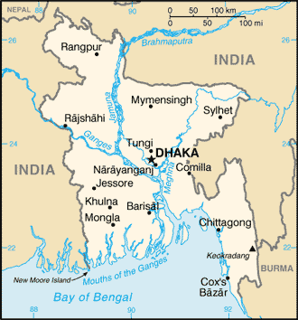
Country of Focus: Bangladesh

Bangladesh is located in southern Asia and is bordered on the west, north, and east by India and the south by the Bay of Bengal. Bangladesh has a population of 144 million people in which 77% live in rural areas (Pulsipher & Pulsipher, 2008). It is the “world’s most densely populated agricultural nation” (Pulsipher & Pulsipher, 2008). The land is very overcrowded and people are trying to manage as farmers. In this country, 43 million people have an insufficient caloric intake; it is not sufficient enough to meet the minimum energy requirements of daily living (Pulsipher & Pulsipher, 2008). About half of the children are underweight for their age. Contraceptives are becoming more and more available as 58% of females are using some sort of birth control (Pulsipher & Pulsipher, 2008). Infant mortality has dropped, and there has been a reduction in fertility rates; fertility rates dropped from 7 children per woman in 1974 to 3 in 2005 (Pulsipher & Pulsipher, 2008). Before it became an independent state, it was the eastern province of Pakistan; this was known as East Bengal and later known as East Pakistan. It is a tropical country lying mainly on large river’s deltas flowing from the Himalayas (“Bangladesh Overview,” 2011). During the rainy season, the land area is covered mostly by floodwater, resulting in damaged crops and damaged economy. Approximately 88% of the people are Muslims; Bangladesh is the world’s largest Muslim country (“Bangladesh Overview,” 2011). Only about 10% of the people are Hindu. Within the country, railways and waterways are the main form of transportation. Because of the number of rivers and annual flooding, it is difficult to construct and maintain adequate transportation facilities (“Bangladesh Overview,” 2011).
References:
Asia and the pacific. (2011). Encyclopedia of the Nations. Retrieved from http://www.nationsencyclopedia.com/economies/Asia-and-the-Pacific/index.html
Bangladesh overview. (2011). Encyclopedia of the Nations. Retrieved from http://www.nationsencyclopedia.com/Asia-and-Oceania/Bangladesh.html
Basnyat, K. (2008, June 22). Managing south asian natural resources. Retrieved from http://www.shvoong.com/exact-sciences/1821455-managing-south-asian-natural-resources/
Introducing the western ghats. (2009, February 17). Retrieved from http://www.lonelyplanet.com/india/tamil-nadu/the-western-ghats
Major rivers of the middle east. (n.d.). World Atlas. Retrieved from http://www.worldatlas.com/webimage/countrys/meriv.htm
Palk strait. (2008). The Columbia Encyclopedia, Sixth Edition. Retrieved from http://www.encyclopedia.com/topic/Palk_Strait.aspx#1
Pulsipher, L.M., & Pulsipher, A. (2008). World regional geography: global patterns, local lives (4th ed.).
New York, NY: W.H. Freeman and Company.
Thar desert. (2008, September 21). The Encyclopedia of Earth. Retrieved from http://www.eoearth.org/article/Thar_desert
The himalayas. (n.d.) Retrieved from http://library.thinkquest.org/22642/nwonders/himalaya.htm
The University of Texas at Austin. University of Texas Libraries: Perry-Castaneda Library Map Collection. Bangladesh small map, 2010. Retrieved from http://www.lib.utexas.edu/maps/cia10/bangladesh_sm_2010.gif
The University of Texas at Austin. University of Texas Libraries: Perry-Castaneda Library Map Collection. India political map, 2001 Retrieved from http://www.lib.utexas.edu/maps/middle_east_and_asia/india_pol01.jpg
