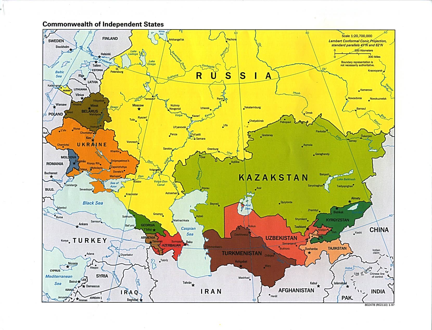
RUSSIA AND THE NEWLY INDEPENDENT STATES
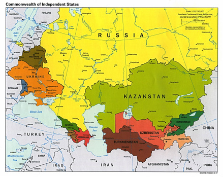
Countries Present in this Region: 12
Russia, Kazakhstan, Kyrgyzstan, Tajikistan, Uzbekistan, Turkmenistan, Azerbaijan, Armenia, Georgia, Ukraine, Moldova, Belarus
Physical Features:
To the east of the Ural Mountains in central Russia stretches the West Siberian Plain to the Yenisey River;it is the largest in the world (Pulsipher & Pulsipher, 2008). This large, continuous, wet lowland occupies almost 1.2 million square miles. The Ob River and its tributaries, which flow north to the Atlantic Ocean, drain this plain (Pulsipher & Pulsipher, 2008). In the northern half of this plain, the winters are long and cold. Because of these cold temperatures, permanently frozen soil is found a few feet below the surface (Pulsipher & Pulsipher, 2008). Frozen soil in the extreme north is found a few inches below the surface (Pulsipher & Pulsipher, 2008). Migratory birds come to this location in the summer as the water cannot pass through the permanently frozen soil; because of this, wetlands/swamps are formed (Pulsipher & Pulsipher, 2008). Although the harsh climate makes extraction difficult, large oil and natural gas reserves are found here (Pulsipher & Pulsipher, 2008).
The Volga River is the longest river in Europe with a length of 2,193 miles flowing north to south (“Volga River,” 2011) It starts northwest of Moscow in the Valdai Hills and empties into the Caspian Sea in the southwest (“Volga River,” 2011). This river is used for transportation, flood control, irrigation, and producing power making it a major part of the Russian peoples’ lives (“Volga River,” 2011). It is a principle waterway and major transport route in Russia. “Canals, lakes, and natural tributaries” connect the river to parts in the North European Plain, along with the Baltic Sea, White Sea, and Black Seas (Pulsipher & Pulsipher, 2008).
Forming the boundary between Europe and Asia, the Ural Mountains extend 1,500 miles north to south; they extend from the Arctic Ocean to the country of Kazakhstan (Maynard, 2004). This mountain range has generally low peaks ranging from 2,000 to 4,000 feet. Its highest peak is at 6,214 feet in elevation and is known as the “People’s Mountain” or Gora Narodnaya (Maynard, 2004). There are five regions to the Ural chain; Arctic Urals, sub-Arctic Urals, North Urals, Middle Urals, and the South Urals. Because there are many passes across the Ural Mountains, they are not much of a barrier to humans (Pulsipher & Pulsipher, 2008). These mountains used to be full of dense forest; however, much of the forests have been cleared for the new industrial cities established in the twentieth century (Pulsipher & Pulsipher, 2008). These two cities are named Yekaterinburg and Chelyabinsk.
The Sea of Azov is located off of the southern shore of both Ukraine and Russia. It is an inland sea that forms the north extension of the Black Sea and is linked on the south by the Kerch Strait (“Sea of Azov,” 2011”). It has an area of approximately 14,500 square miles and is 210 miles long by 85 miles wide (“Sea of Azov,” 2011). The great Don and Kuban rivers, along with many smaller rivers, flow into this sea; the Don and Kuban Rivers bring much silt into the sea. The sea’s floor is pretty much level, with a maximum water depth of only 46 feet; it is “the world’s shallowest sea” (“Sea of Azov,” 2011”). Freight ships carry hard coal, iron ore, metals, fish, grain, salt, and wood; passengers are also transported on this sea. Summers here are warm and dry on the Azov coast, making it important for holiday resorts because the beaches are sandy.
Located to the south of Eastern Siberia in Russia lies Lake Baikal; the deepest lake in the world. It covers approximately 19,573 square miles (Babanine, 2009). The lake is about 395 miles long with an average width of about 30 miles; its widest point is 49 miles (Babanine, 2009). The average depth of the water is 2,395 feet, with a maximum depth in the middle of 5,315 feet (Babanine, 2009). This lake contains about one fifth of the world’s fresh surface-water; it also contains 80% + of the former Soviet Union’s fresh water (Babanine, 2009). This lake is completely surrounded by mountains on all sides. Lake Baikal hosts over 1,000 plant species and 1500 species and varieties of animals (Babanine, 2009).
Climate:
The majority of Russia lies on the north part of the Eurasian landmass in which has a harsh, continental climate (Pulsipher & Pulsipher, 2008). No other place in the world, besides Antarctica, has such a harsh climate. Russia mainly has two Cool Humid Climates; continental, winter dry and continental, moist all year (Pulsipher & Pulsipher, 2008). In these climate zones, the winters are long, cold, and have very few hours of daylight; the summers are short, temperatures range from cool to hot, and days are long (Pulsipher & Pulsipher, 2008). Over the course of the year, something known as continental breathing occurs. This is when summers are breathed in (inhaled) and winters are breathed out (exhaled); summer winds blow to the land from the ocean and winter winds blow the opposite way (Pulsipher & Pulsipher, 2008). This breathing is dominated in the winter as “long, dry, frigid” air is exhaled, flowing out of the arctic zones in the far north of the region (Pulsipher & Pulsipher, 2008). Ocean winds bring little moisture in the summer. The Atlantic Ocean to the west brings warm air, along with smaller amounts of air from the Pacific Ocean to the east; however, in the south, the Indian Ocean cannot blow the warm, wet air to the region as mountain ranges barricade it (Pulsipher & Pulsipher, 2008). Storms from the Atlantic Ocean bring the majority of the rainfall to the region, however, most of the moisture from the air masses dumps over the countries of Europe before getting into the region. Ukraine, Azerbaijan, and the western portion of Russia do get some moisture from the air masses (Pulsipher & Pulsipher, 2008). Countries near the Caucasus Mountains (Georgia, Armenia, Azerbaijan) have a generally warm have plentiful precipitation for agriculture. Lands east of the Ural Mountains, including the lands of Siberia, have cold, lengthy winters and receive little moisture (Pulsipher & Pulsipher, 2008). Drier climates are found in the lands east of the Caucasus Mountains. These semi-arid to arid climates are made possible as they lie in the center of a rather big continent (Pulsipher & Pulsipher, 2008). Summers are dry and rather hot, while winters are intense (Pulsipher & Pulsipher, 2008).
Resources:
This region has significant amounts of natural resources. The world’s largest natural gas reserve is in Russia, along with major oil deposits, and forests running horizontally in the northern parts of the region (Pulsipher & Pulsipher, 2008). Russia also has major coal deposits and industrial materials including iron ore, lead, copper, mercury, nickel, platinum, gold, and hydropower (Pulsipher & Pulsipher, 2008). In fact, the world’s third-largest hydropower producer is Russia. Russia is self-sufficient in almost all major industrial raw materials; there are at least some reserves of every valuable non-fuel industrial mineral (Curtis, 1996) At least 50% of the oil reserves in Russia are located in the Far East; this is important as the demand for oil is rising in Asia (Pulsipher & Pulsipher, 2008). With the abundance of both oil and natural gas, this region is self sufficient in energy and export large amounts of fuels; primary money makers for the economy were both fuels for the Soviet Union and remain in the Russian Federation (Curtis, 1996). The Siberian forests contain approximately one fifth of the world’s timber; it contains mainly conifers (Curtis, 1996).
Environmental Issues:
In Siberia, lakes, rivers, and wildlife have been contaminated with the “world’s worst inland oil spills” (Pulsipher & Pulsipher, 2008). The development of a 2,500 mile oil pipeline threatened one of the least damaged lakes in the region, Lake Baikal. This pipeline would carry Russia’s oil to markets in the Asian Pacific. Because of both local and international protests, it was agree to direct the pipeline a safe distance away and around the lake (Pulsipher & Pulsipher, 2008). Another environmental issue is urban and industrial pollution. In this region, there are few urban sewage systems that “process and purify the sewage that enters them” (Pulsipher & Pulsipher, 2008). Because industrial areas are located close to residential areas, many people are exposed to the harmful byproducts of industrial pollution. These industries can produce smoke, among many other airborne toxins that can cause respiratory problems and difficulties. Because more and more people are buying vehicles, the amount of fossil fuels that are being burned is leading to higher rates of air pollution (Pulsipher & Pulsipher, 2008). The world’s worth nuclear pollution is located in this region. In Kazakhstan, the Soviet military set off approximately 500 nuclear explosions during the cold war; this resulted in people suffering from radiation sickness and birth defects (Pulsipher & Pulsipher, 2008). In 1986, there was a power plant explosion at Chernobyl in north-central Ukraine resulting in 5,000 deaths, 30,000 disabled people, and 100,000 home evacuations (Pulsipher & Pulsipher, 2008).
Population Patterns:
The dominant people in the region, for thousands of years, were people who lived on what their herds of animals provided; meant, milk, and fiber; these people were known as the nomadic pastoralists (Pulsipher & Pulsipher, 2008). These nomads overtook settled communities by using their horsemanship and hunting skills (Pulsipher & Pulsipher, 2008). The people who were permanently settled lived in safe and secure towns in order to keep safe and defend themselves (Pulsipher & Pulsipher, 2008). Central Asia, Ukraine, and Russia were the areas in which the majority of towns arose, because of the dry area of Central Asia and the moist, forested areas of Russia and Ukraine (Pulsipher & Pulsipher, 2008). Central Asia was supportive to settled communities and some large empires about 5,000 or so years ago. The large empires had irrigated crops and had the trading route between China and the Mediterranean (Pulsipher & Pulsipher, 2008). Different groups of farmers, known as the Rus and Slavs, started to appear in the countries today of Belarus, Poland, and Ukraine around 1,500 years ago (Pulsipher & Pulsipher, 2008). They established many settlements as they traveled east, two towns including Kiev and Moscow. Land around the rivers located west of the Ural Mountains was the Slav’s trading towns in the 600’s; their trade routes and the beginning of Christianity helped develop major kingdoms in Ukraine and European Russia (Pulsipher & Pulsipher, 2008). The Mongols conquered the forests of Ukraine and Russia in the twelfth century and had conquered the Silk Road trade route’s empire by the thirteenth century (Pulsipher & Pulsipher, 2008). In 1552, the Mongols had become powerful enough and were able to conquer the Mongols thus beginning the Roman empire expansion (Pulsipher & Pulsipher, 2008). Roman’s around the Moscow area conquered and integrated many of the former Mongol territories, stretching out their empire towards the Baltic Sea by 1600 (Pulsipher & Pulsipher, 2008). Non-Russian people began to occupy areas to the south and east of the Ural Mountains, which lied outside of the empire as there were rich mineral deposits in this area (Pulsipher & Pulsipher, 2008). Western Siberia was the first area outside of Russian territory that was taken over; this expansion between the eighteenth and nineteenth century prompted Russian laborers to migrate to this area (Pulsipher & Pulsipher, 2008). With all of the migration, the original Siberians were outnumbered by the Russians (Pulsipher & Pulsipher, 2008). Also in the nineteenth century, Central Asia was conquered by Russia.
Today, European Russia is the most settled area within the region with approximately 22 people/square mile (Pulsipher & Pulsipher, 2008). Another densely populated area in the region is a “wedge stretching from Odesa in southern Ukraine on the Black Sea north to St. Petersburg on the Baltic Sea and east to Novosibirsk, the largest city in Siberia” (Pulsipher & Pulsipher, 2008). In Siberia, all but 10% of its people live in a small amount of good-sized urban areas. Since the early 1990’s, the population and overall well-being of this region’s population has declined; adult life spans declined and large groups of infants and children passed away (Pulsipher & Pulsipher, 2008). Apparently, mental anxiety and grief from lost jobs has contributed to the lower life expectancies. Divorce rates, suicide rates, and alcohol abuse rates rose by 1996 (Pulsipher & Pulsipher, 2008). A decline in birth rates and environmental pollution also contributes to the region’s population patterns (Pulsipher & Pulsipher, 2008).
Role of Gender:
Because females are encouraged to work outside of the home, the majority of the region’s females are either working as laborers in factories or out in the field (Pulsipher & Pulsipher, 2008). All but 10% of suitable women in this region were full time-workers by the 1970’s; this gave Russia the highest rate of paid female workers in the world (Pulsipher & Pulsipher, 2008). Women do what is known as the double day in which they work long days, both in the home and at work; they cook, clean, care for their kids, and do other household chores when they get home from work. Starting in the 1990’s, female laborers were more educated than the male laborers, and is still true as of 2006 (Pulsipher & Pulsipher, 2008). Both males and females in Central Asia are less educated. The highly educated women in this region tend to have jobs as “economists, accountants, scientists, and technicians;” however, supervisory positions are uncommon (Pulsipher & Pulsipher, 2008). On average, women are paid 36% less than men as of 2005. High-end/high salaried physicians and supervisory engineers are generally males (Pulsipher & Pulsipher, 2008). Although there are high percentages of women working in this region, they have a much lower political status compared to males. After the fall of the Soviet Union, women have not done well with the election process. In Belarus, there are up to 30% of women in the legislature which is higher now than before; however, in Kyrgyzstan, there aren’t any women in the legislature (Pulsipher & Pulsipher, 2008).
Religions:
The Russian Orthodox Church goes back all the way to the “Kievan Rus” period; this was “the first organized Russian state” (“Russia Religions,” 2011). It has a strong political and spiritual influence on Russia’s inhabitants (Curtis, 1996).As of 2001, the largest number of registered religious groups was the Russian Orthodox Church, which had over 10,900 groups (“Russia Religions,” 2011). Approximately 75% of Russia’s people “describe themselves as religious believers” (Curtis, 1996)). The Orthodox belief is that it’s Christianity’s “true, holy, and apostolic church;” their beliefs are based off both the bible and traditions (Curtis, 1996). An interesting point with this religion is that they heavily emphasize on monasticism and spiritual pursuits, and are also self-governing (Curtis, 1996). Within this religion, there is no separation between church and state. Islam, which is the largest minority religion, had just over 3,000 registered groups (“Russia Religions,” 2011). As of 1996, 19% of the Muslim population professed a belief in this religion (Curtis, 1996). There are six main doctrines that Islam’s follow: God, Angels, Scriptures, Prophets, Resurrection, and Divine Creed (Hakim, 2009). To demonstrate one’s beliefs, Islam’s have duties off of the five pillars of faith; these duties include testimony of faith (Kalima), prayer (Salat), almsgiving (Zakat),fasting (Sawm), and pilgrimage (Hajj) (Hakim, 2009 ). The third largest group is Protestants with a variety of denominations; Baptists, Lutherans, Presbyterians, and more (“Russia Religions,” 2011).
Transportation:
Cities in eastern Russia and Central Asia are linked mainly by rail and air as the existing roads have poor quality (Pulsipher & Pulsipher, 2008).There is generally at least one airport in every city in Russia. The Trans-Siberian Railroad connects Moscow to Vladivostok, which is the major port on the Pacific coast of Russia (Pulsipher & Pulsipher, 2008). European Russia has the majority of roads existing in this region; there is a lot of traffic congestion since car ownership has almost tripled and the roads are very narrow and only two lanes (Pulsipher & Pulsipher, 2008). European Russia has a regular rail service with a dense network as it connects industrial cities and resources Pulsipher & Pulsipher, 2008). Car ownership all over Russia is very low, however, light rails/underground commuter systems are only found in six cities. Because transport systems are underdeveloped, international trade has been a problem; the railways and roads they do have are not always foreign-trade friendly (Pulsipher & Pulsipher, 2008).
Railroads throughout Russia are an important mode of transportation with a total of 54,160 miles of railway in 2001 (“Russia Overview,” 2011). As of 2002, there were a total of 591,573 miles of roadway throughout Russia, with approximately 124,000 miles of them being unpaved (“Russia overview,” 2011). Marine access is also important; merchant fleet had about 888 ships in 2002 (“Russia Overview,” 2011). Russia has many important ports, and a new port, handling oil shipments, is scheduled to open sometime in the 21st century from the Baltic Sea (“Russia Overview,” 2011). Water transport is the cheapest way in this region; however, primary transport needs run east to west, and the Russian rivers run north to south (Pulsipher & Pulsipher, 2008).
Cuisine:
Because Russia has cold, long winters, the food Russians eat is aimed at giving them energy and keeping them warm to survive the long winter months. In order to achieve this, the essential components of their meals include fats and carbohydrates, rather than proteins (“Russian food,” 2009). Although they do eat proteins, they eat more carbohydrates and fats. There are five main components in a typical meal: potatoes, bread, butter, eggs, and meat (typically beef) (“Russian food,” 2009). Honey, sugar, apples, milk, sour cream, garlic, and onions are all popular meal components. Russians very seldom use fresh fruits of vegetables (“Russian food,” 2009). Desserts are eaten either after the main course meal, or for breakfast. A few popular desserts include pancakes or cottage cheese in which both are served with honey or jam (“Russian food,” 2009). Pastries, especially apple, Oladi which are the same as pancakes but are thicker and more filling to the stomach, and tvorog burgers served with honey, jam, or sweet dressings are also common (“Russian food,” 2009). Russians typically like authentic beverages; vodka and a berry drink called mors are very common (“Russian food,” 2009). Coffee is popular, along with tea served with sugar and lemon. Kvas is the most popular original Russian beverage; it is a “bread based sweet beverage” (“Russian food,” 2009). Typically, Russian beer is acidic.
Country of Focus: Belarus
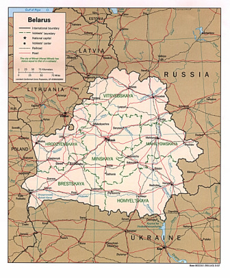
Belarus is located between Poland and Russia and has a total land area of about 207,600 square miles (“Belarus Overview,” 2011). The landscape is flat, forests cover about a third of the country, and thousands of low wetlands, small lakes, and streams are found within the country (Pulsipher & Pulsipher, 2008). The lakes, streams, and marshes have plenty of rainfall to replenish them, averaging about 22-26 inches of precipitation per year (“Belarus Overview,” 2011). Collective farm agriculture cleared a majority of the land; the soil is stony and not very rich (Pulsipher & Pulsipher, 2008). Under its surface, there are not many useful resources or minerals, besides a small amount of oil (Pulsipher & Pulsipher, 2008).Agricultural land and forestland were unusable in 1986 after the country absorbed significant radiation contaminations from the Chernobyl nuclear accident (Pulsipher & Pulsipher, 2008). There are 9.8 million people living in Belarus, with 80% being Belarusian and 13% Russian. The Russian language is popular, and the cultural characteristics of the Belarusian’s are only found in museums and historical festivals (Pulsipher & Pulsipher, 2008). As of 2002, there was 3,432 miles of railways, 61,021 miles of highway, and a total of 136 airports (“Belarus Overview,” 2011). There are no ports or merchant fleets as the country is surrounded by land; canals and rivers are extensive and quite often used.
References:
Babanine, F. (2009, May 05). Lake baikal homepage. Retrieved from http://www.irkutsk.org/baikal/
Belarus overview. (2011). Encyclopedia of the Nations. Retrieved from http://www.nationsencyclopedia.com/Europe/Belarus.html
Curtis, G. (1996). Russia: a country study. Washington: GPO for the Library of Congress. Retrieved from http://countrystudies.us/russia/59.htm
Hakim, S. (2009, March 14). Religion of islam: beliefs. Retrieved from http://www.mnsu.edu/emuseum/cultural/religion/islam/beliefs.html
Maynard, C. (2004). The Ural Mountains. Retrieved from http://books.google.com/books?id=i14UE9_EswIC&printsec=frontcover&dq=ural+mountains&source=bl&ots=00mYLajI41&sig=lheZOnFW_TgY0jsZIO5BJdBjaJc&hl=en&ei=RHhtTafQGIfT4gbImfXTBA&sa=X&oi=book_result&ct=result&resnum=14&sqi=2&ved=0CGcQ6AEwDQ#v=onepage&q&f=false
Pulsipher, L.M., & Pulsipher, A. (2008). World regional geography: global patterns, local lives (4th ed.).
New York, NY: W.H. Freeman and Company.
Russia overview. (2011).Encyclopedia of the Nations. Retrieved from http://www.nationsencyclopedia.com/Europe/Russia.html
Russia religions.(2011). Encyclopedia of the Nations. Retrieved from http://www.nationsencyclopedia.com/Europe/Russia-RELIGIONS.html
Russian food & cuisine- everything about traditional food in russia and authentic russian recipes. (2009, July 31). Retrieved from http://www.waytorussia.net/WhatIsRussia/RussianFood.html
Sea of Azov. (2011). Encyclopaedia Britannica. Retrieved from http://www.britannica.com/EBchecked/topic/46968/Sea-of-Azov
Sourd, G.L., & Rizzolio, D. (2004). Lake Balkhash. United Nations Environment Programme. Retrieved from http://www.grid.unep.ch/activities/sustainable/balkhash/index.php
The University of Texas at Austin. University of Texas Libraries: Perry-Castaneda Library Map Collection. Belarus political map, 1997. Retrieved from http://www.lib.utexas.edu/maps/commonwealth/belarus_pol_97.jpg
The University of Texas at Austin. University of Texas Libraries: Perry-Castaneda Library Map Collection. Commonwealth of independent states political map, 1997. Retrieved from http://www.lib.utexas.edu/maps/commonwealth/commonwealth_pol_97.jpg
Volga River. (2011). Encyclopaedia Britannica. Retrieved from http://www.britannica.com/EBchecked/topic/632239/Volga-River
