EUROPE
Countries Present in this Region: 41
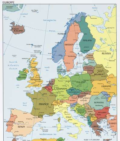
Iceland, Norway, Sweden, Finland, Estonia, Latvia, Lithuania, Republic of Ireland, United Kingdom, Denmark, Poland, Germany, Netherlands, Belgium, Luxembourg, France, Spain, Portugal, Czech Republic, Slovakia, Hungary, Austria, Switzerland, Italy, Slovenia, Croatia, Serbia, Bosnia & Herzegovina, Montenegro, Albania, Macedonia, Greece, Bulgaria, Romania, Cyprus, Vatican City, Malta, Andorra, Liechtenstein, San Marino, Monaco
Physical Features:
The Rhine River starts in the mountains of southeastern Switzerland [Swiss Alps] and ends in the North Sea. It starts out by flowing west, forming Switzerland’s northeast border with Germany. It then goes north, forming part of Germany’s border with France, dissects into the Netherlands, and stops in the North Sea (“Major Rivers”). The river’s total length is approximately 820 miles. This river carries the most traffic out of any other European river, and is the route for many railways and roadways as it cut through the Alps mountain chain and uplands toward the North Sea (Pulsipher & Pulsipher, 2008). Where the river stops, at the Dead Sea, is known as “the economic core of Europe,” and Europe’s biggest port, Rotterdam, is located at the river’s end (Pulsipher & Pulsipher, 2008). In the Swiss Alps, the Rhine River is a small stream. As it flows along to Lake Constance in the northern foot of the Alps, it is a major drinking water source for many parts of southern Germany.
Starting in the mountain range of Germany, the Danube River flows southeasterly across central Europe and ends in the Black Sea. It is approximately 1,771 miles in length, which is more than double the length of the Rhine River (“Major Rivers”). It is the second largest river in Europe, trailing behind the Volga River (“Danube,” 2008). It flows from Germany to Austria, to Slovakia & Hungary, to Croatia & Serbia, to Romania & Bulgaria (Pulsipher & Pulsipher, 2008). It flows through and passes Vienna, Budapest, and Belgrade; these cities are both important and ancient (Pulsipher & Pulsipher, 2008). The Danube River forms the Slovakia and Hungary border, all but a third of the Croatia and Serbia border, part of the Serbia and Romania border, and the majority of the Romania and Bulgaria border (“Danube,” 2008). The Danube is important as barges from Ulm can navigate through; however, the “Danubian commerce” is much less in volume that that of the Rhine (“Danube”, 2008). Because of pollution, the water is not suitable for drinking or irrigation, and the “once-rich fishing grounds” have depleted (“Danube,” 2008).
The border between Spain and France was naturally formed by the Pyrenees. These mountains extend from the Bay of Biscay in the west, easterly to the Mediterranean Sea totaling 270 miles (“Major landforms”). The mountains highest point, Pico de Aneto, is at 11,168 feet in elevation and is located in the central portion of the mountains (“Major landforms”). Crystalline rock is found in higher elevations, and in lower elevations one can find folded limestone; glaciers are absent. There is plenty of timber and pastures found in the Pyrenees and hydroelectric power stations use many of the streams (“Pyrenees,” 2008). Much of the population takes part in agriculture and stock raising (“Pyrenees,” 2008).
The biggest and broadest European landform is the North European Plain, a coastal lowland. It starts along the western Atlantic coast of France, extending to the North Sea, Denmark, Baltic Sea, and southern Finland, Norway, and Sweden (“Major Landforms”). For almost 2,500 miles, it continues easterly through Poland and starts expanding southerly to northerly all the way to the Ural Mountains in Russia (Pulsipher & Pulsipher, 2008). There are big industrial cities, densely populated rural areas, and many mineral deposits here (Pulsipher & Pulsipher, 2008). By building dikes and wind-powered pumps to drain the land, areas have been changed from marshes and river deltas to farming land, pastures, and urban areas (Pulsipher & Pulsipher, 2008). Farming and agriculture are a huge part of the landscape (“Major landforms”).The land is relatively flat, with a few areas of uplands; the Central Russian Uplands are located within this coastal lowland.
The Carpathian Mountains are the natural border of Slovakia and southern Poland (“Major landforms”). They extend to the south, through Ukraine and end in Romania, totaling about 932 miles. The width of the chain can be anywhere from 7 miles to 311 miles; the widest portions are where the highest altitudes are. This mountain system with many subdivisions is the source of three rivers: the Dniester River, Tisza River, and Vistula River (“Major landforms”). Its highest peak, Mt. Gerlachovkain, is located in north Slovakia and is 8,711 feet in elevation (Major landforms”). Unlike the Alps, the Carpathian Mountains are not covered in snow year round and there are not any glaciers. They are separated from the Alps by the Danube River. For the economy in this area, agriculture, forestry, and tourism are important.
Climate:
In this region, one will find three different climate types. These include the temperate midlatitude, Mediterranean, and humid continental; these are found in different parts of the region. The temperate midlatitude climate is found in northwestern Europe. Here, the Atlantic Ocean has warm water currents that create warm, moist air. The climate is cool, but is generally warmer than places around the world at similar latitudes (Pulsipher & Pulsipher, 2008). The North Atlantic Drift also brings rainfall. The Mediterranean climate is an overall mild climate found in southern Europe. Summers here are warm, dry and sunny, while winters are mild and rainy (Pulsipher & Pulsipher, 2008). The humid continental climate is found on the east side of Europe; it is a more extreme climate as the Atlantic Ocean and Mediterranean Sea are not such an influence (Pulsipher & Pulsipher, 2008). Summers are hot and shorter, winters are cold and longer the further you go north or towards the middle of the continent (Pulsipher & Pulsipher, 2008). In the 1990’s, central and southern Europe had the warmest 10 years in over 150 years; this warm decade and high precipitation amounts may have had something to do with global warming. In 2003, temperatures in England broke all records, reaching 100°F +; because Europe’s people are not used to these high temperatures, they were not prepared. Because of this, global warming may already be affecting this region climate-wise.
Resources:
There are many resources in Europe including coal, iron ore, natural gas, and many important minerals. First of all, the North Sea and areas below the Netherlands have large gas and oil deposits (Pulsipher & Pulsipher, 2008). This supplies much of West Europe’s energy that is used. Germany has a lot of iron ore, coal, and natural gas production; they are also known for exporting many construction materials (“Europe Natural Resources,” 2008). Iron ore today is used for a wide variety of things including making metal and metal is used for making many things also. Italy has many important natural resources of Europe including coal, marble, mercury, zinc, nickel, sulfur, uranium, and copper (“Europe Natural Resources,” 2008). Norway exports oil and gas to the European Union as it uses hydropower to supply its energy needs (Pulsipher & Pulsipher, 2008). Because of this oil and gas supply, it is one of the wealthiest countries in the region. Sweden and Finland have the majority of the forests remaining in Europe; they produce timber and wood pulp (Pulsipher & Pulsipher, 2008). The northern part of the Atlantic Ocean, the southern part of the Arctic Ocean, and the North Sea are important for fishing; this is an important resource for Northern European countries and countries along the Atlantic Ocean (Pulsipher & Pulsipher, 2008).
Environmental Issues:
Air pollution and pollution of the seas are two environmental issues of this region. Approximately ¼ of the world’s carbon monoxide is produced by this region’s fossil fuel burning (Pulsipher & Pulsipher, 2008). All over Europe is significant air pollution, however, the North European Plain has much of it. There are many industries, large transportation routes, and high populations with wealthy people; this leads to high fossil fuel use and carbon dioxide production which can cause acid rain (Pulsipher & Pulsipher, 2008). This acid rain threatens the majority of Europe (Pulsipher & Pulsipher, 2008). The Mediterranean Sea is basically a container for many pollutants coming from the lands surrounding it. Sewage (in which only 25% is treated), sediments from erosion, industrial wastes, chemicals from agriculture, nuclear contaminants, and oil spills invade the sea (Pulsipher & Pulsipher, 2008). Because of this pollution, there are wastes floating on top of the water. Few fish can be caught from the sea as it is unfavorable to “natural-life forms” and the water is not swimmable (Pulsipher & Pulsipher, 2008). It is said that it takes over 80 years to flush out the polluted water, especially since the opening to the ocean is quite small.
Population Patterns:
By 200 C.E., there were many towns throughout Europe, many with only about 2,000 people (Pulsipher & Pulsipher, 2008). Between 450-1500 C.E, several of these towns went into ruin; however, some northern Italy cities established trading links both by land and sea (Pulsipher & Pulsipher, 2008). With a large amount of cash being invested into industrialization, Europe became wealthy after the 1500’s. Workers from rural areas and even factory towns migrated to the region as “mining, milling, and manufacturing” activities became apparent (Pulsipher & Pulsipher, 2008). Europe had two of the largest cities by 1800, with populations of over a million people. These cities, London and Paris, are now world cities (Pulsipher & Pulsipher, 2008). The population of Europe is not distributed evenly, and it houses approximately 525 million people (Pulsipher & Pulsipher, 2008). Highly dense areas of Europe include the United Kingdom, the north coast of France, the Netherlands, central Germany, Ukraine, and the northern section of Italy (Pulsipher & Pulsipher, 2008). Along with many other areas, a dense population is found in southeastern European countries. The northern portions of Norway, Sweden, and Finland are much less dense than other areas. In the northern part of Europe, all but 28% of the population live in urban areas; in central Europe, all but 38% of the population live in cities (Pulsipher & Pulsipher, 2008). Land in Europe is both lacking and expensive; very few people in Europe live in single-family homes. Single-family homes are often “attached or densely arranged on small lots” (Pulsipher & Pulsipher, 2008). Families in Europe are having less children; one child in the family is very common throughout Europe. Death rates exceed birth rates because the age of the population is high (Pulsipher & Pulsipher, 2008).
Role of Gender:
The public opinion in Europe still believes that women aren’t as capable of performing the work that is usually done by men. It is also believed that men have less skills of performing household duties (Pulsipher & Pulsipher, 2008). Women do the household chores, while the men do the masculine work. Many European women desire professional careers are working outside of the home (Pulsipher & Pulsipher, 2008). Women do what is called a double day if they work outside of the home, because they are expected to do household duties as well (Pulsipher & Pulsipher, 2008). Women expected to do the double day often choose closer to home jobs that have more flexibility, however they pay less and have fewer chances of advancement (Pulsipher & Pulsipher, 2008). The majority of female Europeans have 3 to 5 hour longer working days than males. European men usually rank higher on the social status than females, and they generally have a higher rate of pay; females make up to 15% less than males doing the exact work (Pulsipher & Pulsipher, 2008). In 2006, there were less unemployed males than females; only a small percentage of men’s jobs were part time compared to the 32% part time female jobs (Pulsipher & Pulsipher, 2008). In Europe’s national parliaments, men make up more than 2/3 of elected representatives; this means less than a third of women are elected representatives (Pulsipher & Pulsipher, 2008).
Religions:
Christianity has been the largest religious group in this region. Europeans call themselves/describe themselves as Christians, but they are separated into different denominations. Roman Catholics and Protestants are two of the main denominations in Europe. Religion has in influence on art, culture, philosophy, and even law. The Catholic Church has dominated the majority of Europe since latter Roman times, accounting for about 45% of the region’s population (Hartig, 2009). The Catholic Church rules and influences religion and also politics and daily life. These Roman Catholic Churches’ practices involved public participation in which there were religious discussions and a printed bible. During the Roman time, church services were only held in the Latin language; few people knew this language (Hartig, 2009). Protestants account for approximately 25% of the region’s population (Hartig, 2009). A movement in the 1500’s, known as the Protestant Reformation, protested and disputed practice of the Roman Catholics leading to the formation of Protestant churches. This reformation helped with the invention, by Johannes Gutenberg, of European’s version of the printing press (Pulsipher & Pulsipher, 2008). With this invention, it increased literacy and helped develop written versions of local languages; it also helped disperse reformist ideas (Pulsipher & Pulsipher, 2008). Protestants promoted individual responsibility. They also made it so social issue debates were made more public and open (Pulsipher & Pulsipher, 2008).
Transportation:
Many different types of transportation are used throughout Europe including railways, airplanes, buses, and cars. Fast Rail Networks, part of European’s rail system, are used for both passengers and cargo. The rail system is extensive, and is constantly getting faster and faster as it competes with budget airlines. It is the primary and major mode of transportation throughout the region. A legend trail, named The Orient Express, passes through 13 European countries; it is the most famous intercontinental train that starts in London and passes through great European cities (“Europe Transportation,” 2010). The “High Speed Train”, the TGV or Train a Grande Vitessa, connects cities across France and its bordering countries. It held the world’s speed record of rails (357 mph) for many years, until recently (“Europe Transportation,” 2010). Airplanes are a faster way of transportation compared to cars and railways. The cost of flights has gone down drastically over the years, for both traveling outside and inside of Europe. Flights help tourism and one can stay at a place longer without having to plan for long travel times. One can also see the beautiful features of Europe from overhead. Buses are not as extensive as railways, but allow people to visit offbeat places that would be missed otherwise (“Europe Transportation,” 2010). Bus stations are generally located at the centers of the cities; if not, they are otherwise close to train stations. Lastly, cars are a popular mode of transportation also; however, people in Europe like the fast rail networks rather than the multiple lane highways for cars and trucks (Pulsipher & Pulsipher, 2008). To transport goods, waterways are used throughout Europe (Pulsipher & Pulsipher, 2008).
Health Care Practices:
Europe has universal health care systems that provide high qualities of care at lower costs than that of the United States. It provides to all people living in Europe, unlike the 47 million that lack health care coverage in the United States; it is mandatory/automatic for everybody (Neel, 2008). Europe uses high-tech medicines, just like the United States, but they use it sparingly. With the universal health care system, longer periods of hospitalizations are preserved to promote gradual healing (Andres, 2007). The countries in Western Europe have the highest measures of good health. Various countries within Europe have different health systems. Britain, among other countries, base their healthy systems off of “the social solidarity principle” (Neel, 2008). Many countries have nationalized health care; other countries build their system around “privately owned insurance companies,” private practice doctors, or religious/private institution-owned hospitals (Neel, 2008). European countries have different access to technology. The technology is Germany and Switzerland is comparable to the technology in the United States; however, many other countries lack in technology (Andres, 2007). Even if there is a lack in technology, patients get to spend more time with doctors and have longer hospitalizations (Andres, 2007).
Country of Focus: Germany

Germany is located in western Germany. It lies between France and Poland, and it borders the North Sea. It has a total area of about 138,000 square miles. In the west side of Germany, the Rhine River and two of its main tributaries dominate the area; this is the most important waterway in Europe carrying more freight than any other waterway (“Brazil Overview,” 2011). In southern Germany, the Danube River flows from west to east. Germany has a temperate climate; the coldest month of the year is January, in which temperatures range from 21-35 °F. In the warmest month of the year, July, temperatures average between 64-68 °F. All year long there is precipitation; average amounts range from 20-80 inches yearly. From January to March, the higher elevation mountains are snow covered. In 2003, there was an estimated population of 82.5 billion people, with 88% of the people living in urban areas (“Brazil Overview,” 2011). Also in this year, approximately 16% of the population was 65 years +, and another 16% were under the age of 15. For every 100 females in the country, there were 96 males (“Brazil Overview,” 2011). Germany is known for their large amount of iron ore, coal, and natural gas production; they are also known for exporting many construction materials (“Europe Natural Resources,” 2008). Health insurance is available to everyone in Germany; this country’s health expenditures are one of the highest in the world (“Brazil Overview,” 2011).
References:
Andres, B. (2007, April 10). Health care like the Europeans do it. CBSNEWS. Retrieved from
http://www.cbsnews.com/stories/2007/04/10/opinion/main2667482.shtml
Danube. (2008). The Colombia Encyclopedia, Sixth Edition. Retrieved from
http://www.encyclopedia.com/topic/Danube.aspx#1
Europe natural resources. (2008). Retrieved from
http://www.europeword.com/blog/europe/europe-natural-resources/
Europe transportation. (2010).Europe Travel Guide.Retrieved from
http://www.europetravelguide.co.uk/post/europe-transportation.html
Germany overview. (2011).Encyclopedia of the Nations. Retrieved from
http://www.nationsencyclopedia.com/Europe/Germany.html
Hartig, O. (2009). Europe. In The Catholic Encyclopedia. New York: Robert Appleton Company. Retrieved from http://www.newadvent.org/cathen/05607b.htm
Major landforms of europe .(n.d.).World Atlas. Retrieved from
http://www.worldatlas.com/webimage/countrys/eulnd.htm
Major rivers of europe (n.d.). World Atlas. Retrieved from
http://www.worldatlas.com/webimage/countrys/euriv.htm
Neel, J. (2008, July 2). Taking the measure of health care in america. NPR. Retrieved from
http://www.npr.org/templates/story/story.php?storyId=92136549
Pulsipher, L.M., & Pulsipher, A. (2008). World regional geography: global patterns, local lives (4th ed.). New York, NY: W.H. Freeman and Company.
Pyrenees. (2008). The Columbia Encyclopedia, Sixth Edition. Retrieved from
http://www.encyclopedia.com/topic/Pyrenees.aspx#1-1E1:Pyren-full
The University of Texas at Austin. (Modified 2011, Feb 25). University of Texas Libraries: Perry-Castaneda Library Map Collection. Europe political map, 2008. Retrieved from
http://www.lib.utexas.edu/maps/europe/txu-oclc-247233313-europe_pol_2008.jpg
The University of Texas at Austin. (Modified 2011, Feb 28). University of Texas Libraries: Perry-Castaneda Library Map Collection. Germany small map, 2010. Retrieved from
http://www.lib.utexas.edu/maps/cia10/germany_sm_2010.gif
